
Page 608 - 9780077418427.pdf
P. 608
/Volume/201/MHDQ233/tat78194_disk1of1/0073378194/tat78194_pagefile
tiL12214_ch23_565-596.indd Page 585 9/23/10 11:07 AM user-f465
tiL12214_ch23_565-596.indd Page 585 9/23/10 11:07 AM user-f465 /Volume/201/MHDQ233/tat78194_disk1of1/0073378194/tat78194_pagefiles
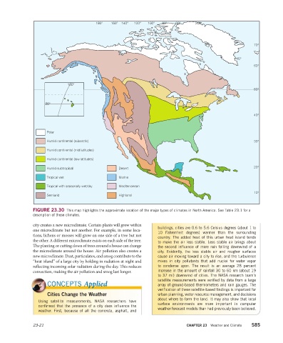
FIGURE 23.30 This map highlights the approximate location of the major types of climates in North America. See Table 23.1 for a
description of these climates.
city creates a new microclimate. Certain plants will grow within
buildings, cities are 0.6 to 5.6 Celsius degrees (about 1 to
one microclimate but not another. For example, in some loca-
10 Fahrenheit degrees) warmer than the surrounding
tions, lichens or mosses will grow on one side of a tree but not
country. The added heat of this urban heat island tends
the other. A different microclimate exists on each side of the tree.
to make the air less stable. Less stable air brings about
The planting or cutting down of trees around a house can change the second influence of more rain falling downwind of a
the microclimate around the house. Air pollution also creates a city. Evidently, the less stable air and rougher surfaces
new microclimate. Dust, particulates, and smog contribute to the cause air moving toward a city to rise, and the turbulence
“heat island” of a large city by holding in radiation at night and mixes in city pollutants that add nuclei for water vapor
reflecting incoming solar radiation during the day. This reduces to condense upon. The result is an average 28 percent
convection, making the air pollution and smog last longer. increase in the amount of rainfall 30 to 60 km (about 19
to 37 mi) downwind of cities. The NASA research team’s
satellite measurements were verified by data from a large
CONCEPTS Applied array of ground-based thermometers and rain gauges. The
verification of these satellite-based findings is important for
Cities Change the Weather urban planning, water resource management, and decisions
about where to farm the land. It may also show that local
Using satellite measurements, NASA researchers have
surface environments are more important in computer
confirmed that the presence of a city does influence the
weather forecast models than had previously been believed.
weather. First, because of all the concrete, asphalt, and
23-21 CHAPTER 23 Weather and Climate 585