
Page 601 - 9780077418427.pdf
P. 601
/Volume/201/MHDQ233/tat78194_disk1of1/0073378194/tat78194_pagefile
tiL12214_ch23_565-596.indd Page 578 9/23/10 11:07 AM user-f465
tiL12214_ch23_565-596.indd Page 578 9/23/10 11:07 AM user-f465 /Volume/201/MHDQ233/tat78194_disk1of1/0073378194/tat78194_pagefiles
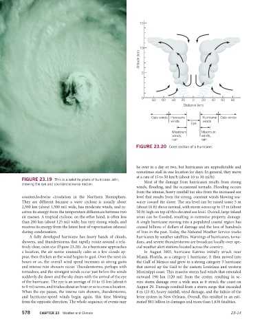
15
10
10
Altitude (km)
5 5
0
80 60 40 20 0 20 40 60 80
Distance (km)
Gale winds Hurricane Hurricane Gale winds
winds winds
Eye
Maximum Maximum
winds, winds,
rain rain
FIGURE 23.20 Cross section of a hurricane.
be over in a day or two, but hurricanes are unpredictable and
sometimes stall in one location for days. In general, they move
at a rate of 15 to 50 km/h (about 10 to 30 mi/h).
FIGURE 23.19 This is a satellite photo of hurricane John, Most of the damage from hurricanes results from strong
showing the eye and counterclockwise motion.
winds, flooding, and the occasional tornado. Flooding occurs
from the intense, heavy rainfall but also from the increased sea
counterclockwise circulation in the Northern Hemisphere. level that results from the strong, constant winds blowing sea-
They are different because a wave cyclone is usually about water toward the shore. The sea level can be raised some 5 m
2,500 km (about 1,500 mi) wide, has moderate winds, and re- (about 16 ft) above normal, with storm waves up to 15 m (about
ceives its energy from the temperature differences between two 50 ft) high on top of this elevated sea level. Overall, large inland
air masses. A tropical cyclone, on the other hand, is often less areas can be flooded, resulting in extensive property damage.
than 200 km (about 125 mi) wide, has very strong winds, and A single hurricane moving into a populated coastal region has
receives its energy from the latent heat of vaporization released caused billions of dollars of damage and the loss of hundreds
during condensation. of lives in the past. Today, the National Weather Service tracks
A fully developed hurricane has heavy bands of clouds, hurricanes by weather satellites. Warnings of hurricanes, torna-
showers, and thunderstorms that rapidly rotate around a rela- does, and severe thunderstorms are broadcast locally over spe-
tively clear, calm eye (Figure 23.20). As a hurricane approaches cial weather alert stations located across the country.
a location, the air seems unusually calm as a few clouds ap- In August 2005, hurricane Katrina initially struck near
pear, then thicken as the wind begins to gust. Over the next six Miami, Florida, as a category 1 hurricane. It then moved into
hours or so, the overall wind speed increases as strong gusts the Gulf of Mexico and grew to a strong category 3 hurricane
and intense rain showers occur. Thunderstorms, perhaps with that moved up the Gulf to the eastern Louisiana and western
tornadoes, and the strongest winds occur just before the winds Mississippi coast. This massive storm had winds that extended
suddenly die down and the sky clears with the arrival of the eye outward 190 km (120 mi) from the center, resulting in se-
of the hurricane. The eye is an average of 10 to 15 km (about 6 vere storm damage over a wide area as it struck the coast on
to 9 mi) across, and it takes about an hour or so to cross a location. August 29. Damage resulted from a storm surge that exceeded
When the eye passes, the intense rain showers, thunderstorms, 8 m (25 ft), heavy rainfall, wind damage, and the failure of the
and hurricane-speed winds begin again, this time blowing levee system in New Orleans. Overall, this resulted in an esti-
from the opposite direction. The whole sequence of events may mated $81 billion in damages and more than 1,836 fatalities.
578 CHAPTER 23 Weather and Climate 23-14