
Page 197 - (DK) Ocean - The Definitive Visual Guide
P. 197
ICEBERGS 195
North Atlantic Icebergs HUMAN IMPACT
Most icebergs seen in the north Atlantic begin as snow falling on ICEBERG DETECTION
Greenland. This snow eventually becomes ice, which over thousands
of years is transported from the Greenland ice sheet down to the sea Because of their threat to shipping,
as glaciers. Icebergs calved from north Atlantic icebergs are
monitored by the US Coast Guard.
ARCTIC OCEAN the glaciers on the west coast Information on iceberg sightings,
Ellesmere Greenland of Greenland (and many from obtained by aircraft and ships, is
Island Arctic circle the east coast) move into Baffin fed into a computer along with
Sea Bay. The Labrador Current ocean-current and wind data. The
carries these icebergs southeast, future movements of the icebergs
ICELAND are then predicted so that ships can
G R E E N
past Newfoundland, into the
Hayes north Atlantic. There, most be warned. The southernmost
iceberg ever spotted in the Atlantic
of the icebergs rapidly melt, was only 155 miles (250 km) from
Humboldt L A N D
Baffin Jakobshavn but a few reach as far south as Bermuda at 32˚N.
Bay
40˚N—around the same latitude
as New York and Lisbon.
ORIGINS AND DISTRIBUTION
C
NORTH Most north Atlantic icebergs are calved
A
by glaciers in west Greenland, such as
ATLANTIC
N
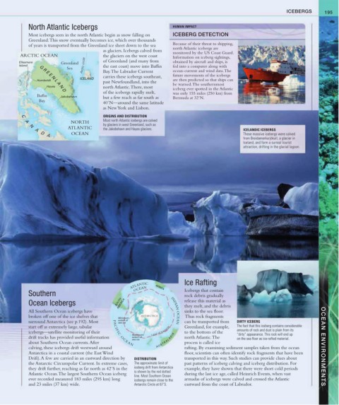
A the Jakobshavn and Hayes glaciers. ICELANDIC ICEBERGS
OCEAN These massive icebergs were calved
D
A
from Breidamerkurjökull, a glacier in
Iceland, and form a surreal tourist
attraction, drifting in the glacial lagoon.
ATLANTIC AFRICA Ice Rafting
OCEAN
Southern Icebergs that contain
rock debris gradually
Ocean Icebergs SOUTH AMERICA release this material as
they melt, and the debris
All Southern Ocean icebergs have Antarctic circle INDIAN OCEAN sinks to the sea floor.
broken off one of the ice shelves that Minimum ANTARCTICA Thus rock fragments
surround Antarctica (see p.192). Most extent of can be transported from DIRTY ICEBERG
sea ice
start off as extremely large, tabular Greenland, for example, The fact that this iceberg contains considerable
icebergs—satellite monitoring of their PACI FI C O C E AN Limit of Icebergs to the bottom of the amounts of rock and dust is plain from its
Maximum “dirty” appearance. This rock will end up
drift tracks has provided useful information extent of north Atlantic. The on the sea floor as ice-rafted material.
sea ice A U S T R A L A S I A
about Southern Ocean currents. After process is called ice
calving, these icebergs drift westward around rafting. By examining sediment samples taken from the ocean OCEAN ENVIRONMENTS
Antarctica in a coastal current (the East Wind floor, scientists can often identify rock fragments that have been
Drift). A few are carried in an eastward direction by DISTRIBUTION transported in this way. Such studies can provide clues about
the Antarctic Circumpolar Current. In extreme cases, The approximate limit of past patterns of iceberg calving and iceberg distribution. For
they drift further, reaching as far north as 42˚S in the iceberg drift from Antarctica example, they have shown that there were short cold periods
Atlantic Ocean. The largest Southern Ocean iceberg is shown by the red dotted during the last ice age, called Heinrich Events, when vast
line. Most Southern Ocean
ever recorded measured 183 miles (295 km) long icebergs remain close to the armadas of icebergs were calved and crossed the Atlantic
and 23 miles (37 km) wide. Antarctic Circle at 67˚S. eastward from the coast of Labrador.