Page 475 - (DK) Ocean - The Definitive Visual Guide
P. 475

MELANESIA        473


                PACIFIC OCEAN C2                                                                         PACIFIC OCEAN K3
             Arafura Sea                                                                              Fiji Plateau

             AREA  251,000 square miles (650,000 square km)                                           AREA  30,900 square miles (80,000 square km)
             MAXIMUM DEPTH  260 ft (80 m)                                                             AVERAGE DEPTH  Less than 820 ft (250 m)
             INFLOWS  Coral Sea, Timor Sea, Banda Sea
                                                                                                      The Fiji Plateau is the thickest part of
             Lying over a shallow continental shelf,                                                  the Fiji Plate. The islands of Fiji were
             the Arafura Sea marks the boundary                                                       originally part of a continuous
             between the Pacific and Indian                                                           volcanic island arc alongside Vanuatu
             oceans. During the Indian summer                                                         and the Solomons. They were moved
             monsoon, water flows westward                              GREAT BARRIER REEF            east when the Pacific Plate changed
             into the Indian Ocean, pulled by    PACIFIC OCEAN G3       The largest coral reef structure in the world,   its direction of motion, triggering the
             the South Equatorial Current, but    Coral Sea             the Great Barrier Reef stretches for more than   creation of new ocean crust in the
             the flow is reversed when the                              1,200 miles (2,000 km).       North Fiji Basin. The Hunter Ridge
             Equatorial Counter Current is    AREA  1.8 million square miles (4.8 million square km)  to the south marks the transform
             active during the Indian winter.  MAXIMUM DEPTH  30,070 ft (9,165 m)  south as the East Australia Current.   fracture that allowed this eastward
                                                                        The eastern and northern sides of    motion, while the Vityaz Trench to
                                           INFLOWS  West Central Pacific Ocean; Fly, Purari,
                                           Kikori rivers                the Coral Sea are marked by deep   the north marks the subduction zone
                                                                        trenches, where the oceanic part    that created the islands, though the
                                           This tropical sea earns its name from   of the Australian Plate is subducting.   trench is now inactive. Over time
                                           the presence of coral reefs along most   Volcanism has resulted in the    a substantial platform of limestone
                                           of its coasts. The Great Barrier Reef   Solomon Islands and the Vanuatu   accumulated around the original
                                           (see p.161) grows out to the edge    chain. Explosive eruptions in these   volcanic islands, as they were uplifted,
                                           of the Australian continental shelf,    islands can create pumice, a volcanic   faulted, and folded by the opening of
                                           on the western side of the sea. Warm   rock that floats due to gas bubbles   the young, buoyant North Fiji Basin.
                                           water enters from the Pacific, circulating  trapped inside. Lumps of pumice are   Growth of the platform continues
                                           weakly before leaving through the   sometimes washed up on the western   today, thanks to the coral reefs that
             SUNSET OVER THE ARAFURA SEA   Torres Strait to the west, or to the   shore of the Coral Sea.  fringe Fiji’s hundreds of islands.
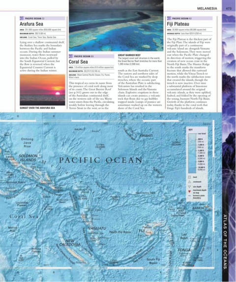

           G                     H                     I                    J                     K                     L
                           160˚E                               170˚E                               180˚                     Equator

                                              NAURU                                                                KEY
                                                        Banaba                 Tungaru
    Lyra                                                                    Gilbert Ridge                                sea level
    Reef                                                                             KIRIBATI
              Ontong                                                                                                     800 ft     1
               Java                                                                                      6,249m          (250 m)
                                                           3,179m                                        (20,503ft)      1,600 ft
               Rise                                        (10,430ft)                                                    (500 m)
    Buka                                                                                                                 3,300 ft
   Island                                                                                                                (1,000 m)
    8,940m  SOLOMON                                                                                                      6,500 ft
    (29,332ft)  ISLANDS              PA CIFIC OCEAN                                                                      (2,000 m)
      Bougainville  Choiseul  M                                                                                          9,800 ft
        Island      7m          e                                                                                        (3,000 m)
                   (23ft) Santa     l                                                                                    16,400 ft
                       Isabel                                                                TUVALU                      (5,000 m)
     399m    New Georgia Sound          a
    (1,309ft)  New Georgia Islands
                              Malaita        n                                                  Funafuti              land          2
                           Honiara
     Solomon Basin       Guadalcanal             e                                                                    seamount
                                San Cristobal        s     Vityaz  Trench                                    10˚S
    Louisiade                     8.322m                                                                              sea depth
     Pockington  Trough                         9,175m                             Hazel Holme Bank                   on map
                                 (27,304ft)
    Archipelago        South Solomon  Trench     Santa Cruz                                                           maximum depth
                                                   Islands i
                                                                                                                      tectonic plate
                           Rennell
                                                                     Bank
                                   Santa Cruz   (30,103ft)  a       Pandora                                    Îles   boundary
          Louisiade                  Basin  Hebrides  Trench                                                 Wallis
           Plateau                                                                                                        Savai’i
                            1,577m                                                                      Île                  Apia
                                             North New
                           (5,174ft)                                                                   Futuna WALLIS  SAMOA
                                                      Banks Islands                                          AND             Upolu
                                                                                                            FUTUNA                  3
                                                  Espiritu
       Coral Sea                                  Santo  Maewo                                           Zephyr Reef
                                                        Pentecost
                                                   Malekula
                                                                                         Vanua Levu
                                                                                         Fiji
      Mellish                                         VANUATU                          Plateau
       Rise                                                        North Fiji Basin  FIJI        Koro  Lau Group
                                                      Efate Port- Vila                   Suva     Sea
                                                                                     Viti Levu                 Lau
                                                            Erromango
                                                       222m                                                   Basin Vava’u
                                         NEW           (728ft)                                          4m          Group                ATLAS OF THE OCEANS
                                     CALEDONIA               Tanna                                     (13ft)           Tonga Ridge Tonga  Trench
                                                                                  New Hebrides  Trench
                    Bellona                                                                                 TONGA             20˚S  4
                    Plateau        New Caledonia  Trough  Loyalty Islands      Hunter Ridge                  Tongatapu
                                                   New Hebrides  Trench
            16m                                                                                         Lau Ridge  Group  10,587m
            (52ft)                                                  7,183m                South Fiji                  (34,736ft)
                                               Nouméa              (23,567ft)               Basin              10,800m
                           160˚E                               170˚E                               180˚        (35,435ft)
           G                     H                     I                    J                     K                     L
   470   471   472   473   474   475   476   477   478   479   480