Page 474 - (DK) Ocean - The Definitive Visual Guide
P. 474

472     THE PACIFIC OCEAN


               Melanesia                                                                                    PACIFIC OCEAN F1
                                                                                                        Bismarck Sea
               THE NAME MELANESIA COMES FROM THE GREEK for “black
                                                                                                        AREA  124,000 square miles (320,000 square km)
               islands.” The area includes the islands north of Australia, from
                                                                                                        MAXIMUM DEPTH  9,200 ft (2,800 m)
               Celebes and New Guinea in the west, to Fiji and Samoa in the
                                                                                                        INFLOWS  Pacific Ocean, Solomon Sea
               east. The surrounding seas are tropical, their warm waters fed by
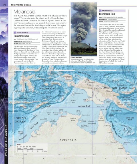
               the westward flow of the South Equatorial Current. The region                            The Bismarck Sea lies off the north
                                                                                                        coast of New Guinea. It is surrounded
               is geologically complex, with some parts volcanically active.                            by volcanic islands, the largest being
                                                                                                        New Britain. The underlying Bismarck
                                             the Solomon Sea appears to consist                         Microplate is caught between
                  PACIFIC OCEAN F2
                                             of one or two very small tectonic                          the Australian Plate, moving north,
               Solomon Sea                   plates (microplates) of oceanic origin.                    and the Pacific and Caroline plates,
                                             The Solomon Sea Microplate is                              moving west. The northern islands
               AREA  278,000 square miles (720,000 square km)  spreading from the area of the           of the archipelago arise from the
               MAXIMUM DEPTH  29,300 ft (8,940 m)  Pockington Trough and rotating                       subduction of the Caroline and Pacific
                                             clockwise, subducting to the north                         plates, marked by the Manus Trench
               INFLOWS  Pacific Ocean, Coral Sea
                                             and possibly to the southwest. Volcanic                    to the north. Volcanoes on the south
               The Solomon Sea lies between the   activity is particularly intense off the              side of the sea are currently more
               Solomon Islands and the island of   New Georgia Islands, where the                       active, arising from the subduction
               New Guinea, with the island of New   spreading ridge is being subducted:                 of the Solomon Sea Microplate at
               Britain to the north and the Louisiade   the submarine volcano Kavachi                   the New Britain Trench. To the east
               Archipelago to the south. The area is   breached the surface explosively in              of the Bismarck Sea lies the Ontong
               geologically complex, forming the   2002. On the other side of the sea,                  Java Rise. This submarine plateau is
               remains of a closing ocean basin   the tectonic upheavals have resulted    RABAUL VOLCANO  one of the world’s largest expanses of
               caught between the Australian Plate   in uplift of New Guinea’s Huon   The sudden eruption of the Rabaul caldera    igneous rock. It is composed of flood
               moving north and the Pacific    Peninsula, where raised coral terraces   on the coast of New Britain forced the   basalts, some of which date back to
               Plate moving west. The floor of    are found some distance inland.  evacuation of the nearby city Rabaul in 1994.  120 million years ago.


                        A                     B                     C                    D                     E                     F
                Equator   120˚E                       Pulau   130˚E                              140˚E                                150˚E
                          Gulf of     Molucca Sea    Halmahera
                          Tomini                       Halmahera                  New Guinea  Trench          Manus  Trench
                      Palu              Kepulauan  M o l u c c a s  Sea  Manokwari
                                                                      Jazirah
                                          Sula
                   Makassar Strait  T eluk Bone  Pulau  Ambon Pulau Seram                Sungai Mamberamo  Sepik  Wewak    Bismarck Sea  Ireland
                                                                                           22m
                                             164m
            1           Celebes              (538ft) Ceram Sea        Doberai              (72ft)                Manus Island
                                                                                             Jayapura
                                                                                                                                         New
                                            Buru
                                                                                                                            Umboi
                                                                                                                            Island
                Makassar    Bone         INDONESIA                                           New Guinea PAPUA   NEW   GUINEA            Rabaul
                                                                                                                Madang
                            Basin           Banda Sea         Kepulauan        Kepulauan Aru     Sungai Digul                     New Britain
                                                                   Kai
                     Flores                                   Kepulauan                                                Lae
                      Sea                    Pulau Kepulauan  Tanimbar                                                           New Britain  Trench
                     Flores Basin            Wetar  Damar
                  Lesser  Sunda  Islands                                                Pulau Yos       Fly                       Solomon Sea
                                                                           Arafura      Sudarso                 Gulf of
            2   Sumbawa   Flores             Dili                           Sea                                 Papua      Port    D‘Entrecasteax
                                             EAST TIMOR
                              Savu Basin                                                                                   Moresby   Islands
                      Palau Sumba  Savu Sea  Timor                                 Arafura Shelf      Torres Strait
               10˚S                         Timor  Trough     Melville                                     Cape York
                                                               Island            Wessel                              Papua Plateau
                                                                                 Islands
                                                  Timor  Bathurst                     Cape Arnhem                  1,337m
                                                          Island
                                                   Sea
                                  Sahul Banks                    Darwin                                  Cape     (4,387ft)
                INDIAN                     Londonderry                    Arnhem       Groote            York                        Coral Sea
                                               Cape
                                                                                                                                      Basin
                                                      Joseph
                OCEAN                                Bonaparte             Land       Eylandt  Gulf of  Peninsula
            3       Rowley       Sahul Shelf           Gulf                          Sir Edward Carpentaria  Cooktown  G r ea t  Ba rr ier  Ree f  (10ft)  Coral
        ATLAS OF THE OCEANS  4  20˚S  SCALE  200  300  400  Broome Derby  A US TRALIA           Islands          Cairns     Mackay  Whitsunday
                                                                                     Pellew Group
                                                                                                                                  3m
                                                                                                                             Queensland Plateau
                                                                                                Wellesley
                                                                                                                                       Sea
                                                                                                                                      Islands
                    Shoals
                     Rowley Shelf
                                                                                                                    Townsville
                                                                                                                                  Group
                   0
                      100
                                   500 km
                   0
                        100
                        A 120˚E 200  300  400  500 miles      130˚E  C                   D       140˚E         E                     F 150˚E
                                              B
   469   470   471   472   473   474   475   476   477   478   479