
Page 479 - (DK) Ocean - The Definitive Visual Guide
P. 479
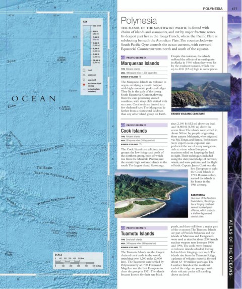
G H I POLYNESIA 477
140˚W 130˚W
Polynesia
KEY
sea level
1 THE FLOOR OF THE SOUTHWEST PACIFIC is dotted with
800 ft chains of islands and seamounts, and cut by major fracture zones.
(250 m)
Its deepest part lies in the Tonga Trench, where the Pacific Plate is
10˚N 1,600 ft
(500 m)
subducting beneath the Australian Plate. The counterclockwise
3,300 ft
(1,000 m) South Pacific Gyre controls the ocean currents, with eastward
6,500 ft Equatorial Countercurrents north and south of the equator.
(2,000 m)
9,800 ft
1,920m (3,000 m) PACIFIC OCEAN G4 Despite this isolation, the islands
suffered the effects of an earthquake
Zone (6,300ft) (5,000 m) 2 Marquesas Islands in Alaska in 1946 when they were hit
16,400 ft
by the resultant tsunami, which rose
TYPE Volcanic islands up to 40 ft (12 m) high in some places.
land
AREA 490 square miles (1,270 square km)
seamount
NUMBER OF ISLANDS 15
sea depth
The Marquesas Islands are volcanic in
maximum depth
on map origin, overlying a mantle hotspot,
tectonic plate with high mountain peaks and ridges.
Equator
boundary They lie in the path of the strong
3 South Equatorial Current, flowing
OCEAN from the east, producing eroded
coastlines, with steep cliffs dotted with
Zone 4,567m sea caves. Coral reefs are limited to a
few sheltered bays. The Marquesas lie
(14,984ft)
farther from a continental landmass
than any other island group on Earth. ERODED VOLCANIC COASTLINE
rises 2,140 ft (652 m) above sea level
PACIFIC OCEAN D5
4 and 14,800 ft (4,500 m) above the
Cook Islands ocean floor. The islands were settled in
about 300 bc by people originating
Nuku TYPE Volcanic islands from eastern Melanesia, who migrated
Hiva
AREA 93 square miles (240 square km) via Fiji, Tonga, and Samoa. Polynesians
were expert ocean explorers and
NUMBER OF ISLANDS 15
Hiva perfected the use of many navigation
Marquesas Fracture Zone The Cook Islands are split into two aids at a time when European
Marquesas Islands
Oa 10˚S
groups: the low-lying coral atolls of
mariners relied on keeping the land
using the stars; knowledge of currents,
rise from the Manihiki Plateau; and
5 the northern group, most of which in sight. Their techniques included
the mainly high volcanic islands in the winds, and wave patterns; and the flight
south. The largest island, Rarotonga, of birds. Captain James Cook was the
Tiki Basin first European to sight
the Cook Islands in
1773. Russian sailors
named the islands in
Tuamotu Fracture Zone
his honor in the
19th century.
6
I s l a n d s
RAROTONGA
Austral Fracture Zone 20˚S Like most of the Southern
Cook Islands, Rarotonga
R i d g e
has a fringing coral reef
several hundred yards
offshore, which protects
a shallow lagoon and
coastal plain.
Îles Gambier
Oeno Island
7
Henderson PACIFIC OCEAN F6 pearls, and these still form a major part
Island Ducie Island of the economy. The Tuamotu Islands
Pitcairn
Island PITCAIRN Tuamotu Islands are part of French Polynesia and the
ISLANDS islands of Mururoa and Fantgataufa
TYPE Coral atoll islands were used as sites for about 200 French
AREA 340 square miles (885 square km) nuclear weapon tests between 1966
and 1996. The atolls were formed
NUMBER OF ISLANDS 78 ATLAS OF THE OCEANS
as volcanic islands subsided, leaving
25m The Tuamotu Islands are the longest behind their fringing coral reefs. The
(82ft) SCALE chain of coral atolls in the world, islands rise from the Tuamotu Ridge,
8
0 100 200 300 400 500 km stretching over 1,200 miles (2,000 a plateau of volcanic material formed
30˚S km). The Tuamotus were settled by about 63–40 million years ago. The
Polynesians by ad 700. Ferdinand Gambier Islands at the southeast
0 100 200 300 400 500 miles
Magellan was the first European to end of the ridge are younger, with
140˚W 130˚W chart the group in 1521. The islands their volcanic peaks still standing
became known for their rare black above sea level.
G H I