
Page 480 - (DK) Ocean - The Definitive Visual Guide
P. 480
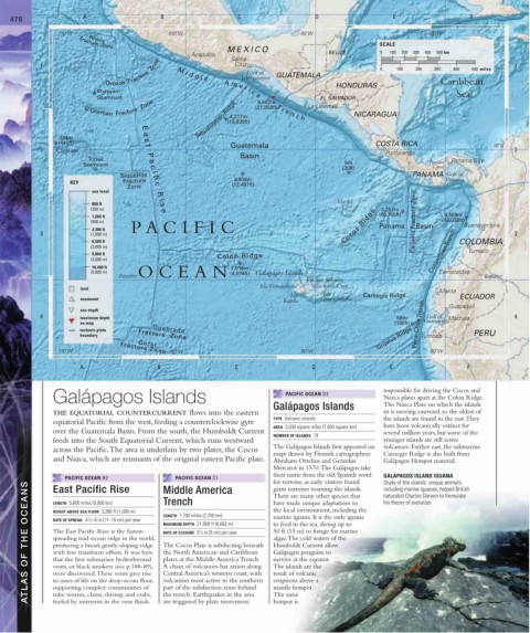
478 A B C D E F
110˚W 100˚W 90˚W 80˚W
Rivera
SCALE
Fracture Zone
MEXICO 0
Acapulco Salina BELIZE 100 200 300 400 500 km
Orozco Fracture Zone Tehuantepec GUATEMALA 0 100 200 300 400 500 miles
1 Cruz 1
Gulf of
HONDURAS Caribbean
Khayyam Sea
Seamount EL SALVADOR
O‘Gorman Fracture Zone (21,858ft) La Libertad
Tehuantepec Ridge 4,217m NICARAGUA
M i d d l e A m e r i c a
6,662m T r e n c h
(13,836ft)
134m E
a
(440ft) s COSTA RICA 10˚N
2 Clipperton t Guatemala Puntarenas 2
Basin
P
Torres a Panama City
Seamount 9m Panama
(30ft) Canal
c
PANAMA Gulf of
i
3,806m
Fracture
KEY Siqueiros fi (12,487ft) Panama
Zone
c
sea level
R
Isla del
i
800 ft s Coco
(250 m) e 3,281m
1,600 ft (10,765ft) 3,669m
(500 m) Panama Fracture Zone (12,038ft) Buenaventura
3,300 ft P A CIFIC Cocos Ridge Panama Basin
3 (1,000 m) 3
6,500 ft COLOMBIA
(2,000 m) Colombian Trench
9,800 ft Colón Ridge Tumaco
(3,000 m)
16,400 ft 1,516m
(5,000 m) EquatorOCEAN (4,974ft) Galapagos Islands Esmeraldas
Isla San Salvador Equator
Isla Fernandina Isla Santa Cruz
land Manta
Isla Isla Carnegie Ridge ECUADOR
seamount Isabela San Cristóbal
sea depth Guayaquil
4 maximum depth 58m Gulf of Machala 4
on map (190ft) Peru–Chile Trench Guayaquil
Grijalva Ridge
tectonic plate Quebrada
boundary Fracture Zone Tumbes PERU
Gofar
110˚W Fracture Zone 100˚W 90˚W 80˚W
A B C D E F
Galápagos Islands PACIFIC OCEAN D3 responsible for driving the Cocos and
Nazca plates apart at the Colon Ridge.
Galápagos Islands The Nazca Plate on which the islands
THE EQUATORIAL COUNTERCURRENT flows into the eastern sit is moving eastward, so the oldest of
TYPE Volcanic islands the islands are found in the east. They
equatorial Pacific from the west, feeding a counterclockwise gyre
AREA 3,030 square miles (7,850 square km) have been volcanically extinct for
over the Guatemala Basin. From the south, the Humboldt Current several million years, but some of the
NUMBER OF ISLANDS 19
feeds into the South Equatorial Current, which runs westward younger islands are still active
across the Pacific. The area is underlain by two plates, the Cocos The Galápagos Islands first appeared on volcanoes. Farther east, the submarine
maps drawn by Flemish cartographers Carnegie Ridge is also built from
and Nazca, which are remnants of the original eastern Pacific plate. Abraham Ortelius and Gerardus Galápagos Hotspot material.
Mercator in 1570. The Galápagos take
their name from the old Spanish word GALÁPAGOS ISLAND IGUANA
PACIFIC OCEAN C1
PACIFIC OCEAN B2 Middle America for tortoise, as early visitors found Study of the islands’ unique animals,
ATLAS OF THE OCEANS HEIGHT ABOVE SEA FLOOR 3,280 ft (1,000 m) LENGTH 1,700 miles (2,750 km) marine iguana. It is the only iguana
East Pacific Rise
including marine iguanas, helped British
giant tortoises roaming the islands.
naturalist Charles Darwin to formulate
There are many other species that
Trench
his theory of evolution.
have made unique adaptations to
LENGTH 5,600 miles (9,000 km)
the local environment, including the
RATE OF SPREAD 4 / 2–6 in (11–15 cm) per year
1
to feed in the sea, diving up to
MAXIMUM DEPTH 21,858 ft (6,662 m)
The East Pacific Rise is the fastest-
50 ft (15 m) to forage for marine
1
RATE OF CLOSURE 3 / 2 in (9 cm) per year
algae. The cold waters of the
spreading mid-ocean ridge in the world,
The Cocos Plate is subducting beneath
producing a broad, gently-sloping ridge
Humboldt Current allow
Galápagos penguins to
the North American and Caribbean
with few transform offsets. It was here
survive at the equator.
plates at the Middle America Trench.
that the first submarine hydrothermal
A chain of volcanoes has arisen along
The islands are the
vents, or black smokers (see p.188-89),
Central America’s western coast, with
were discovered. These vents give rise
result of volcanic
eruptions above a
volcanism most active in the southern
to oases of life on the deep-ocean floor,
supporting complex communities of
part of the subduction zone behind
mantle hotspot.
The same
the trench. Earthquakes in the area
tube worms, clams, shrimp, and crabs,
hotspot is
are triggered by plate movement.
fueled by nutrients in the vent fluids.