
Page 481 - (DK) Ocean - The Definitive Visual Guide
P. 481
EASTER ISLAND 479
Easter Island PACIFIC OCEAN B3 about a century before the first
European explorers arrived. It is
IN THE EASTERN SOUTH PACIFIC, the cold Humboldt Current Easter Island thought that the island’s forests and
soil became so depleted that the
TYPE Volcanic island islanders’ society collapsed in a violent
flows north up the coast of South America, forming the eastern
AREA 63 square miles (164 square km) struggle over access to rapidly
arm of the South Pacific Gyre. It then turns west in the tropics, diminishing resources.
NUMBER OF ISLANDS 1
feeding the South Equatorial Current. In some years, this
current is weakened and warm water pools in the east, disrupting Easter Island lies near the East Pacific
Rise, which separates the Pacific Plate
weather patterns over a wide area of the Pacific Ocean. to the west from the Nazca Plate to
the east. The island is the highest point
by the convergence, creating the of the Easter Fracture Zone, a series
PACIFIC OCEAN F2
Andes Mountains. Melting of the rocks of ridges and trenches marking
Peru-Chile Trench around the subducting slab has led a transform fault running 3,650 miles
to volcanism and many of the Andes’ (5,900 km) across the floor of the
LENGTH 3,650 miles (5,900 km) tallest peaks are volcanoes. Earthquakes South Pacific, from the Peru–Chile
MAXIMUM DEPTH 26,474 ft (8,069 m) along the trench produced nine large Trench in the east to the Tuamotu
tsunamis during the 20th century, Archipelago (see p.477) in the west.
RATE OF CLOSURE 3 in (7.8 cm) per year
resulting in more than 2,000 deaths. Easter Island was named in 1722 by
The Peru–Chile Trench (also called The trade winds drive surface waters Dutch sailors, who came across it
the Atacama Trench) is the longest offshore throughout most years, on Easter Sunday. It had been settled
ocean trench, marking the point at leading to upwelling of nutrient-rich at least 1,000 years earlier by
which the Nazca Plate meets the deep water off the coast of Peru. This Polynesians, who today call the island
South American Plate. The Nazca upwelling makes the water very Rapa Nui. The island is famous for its
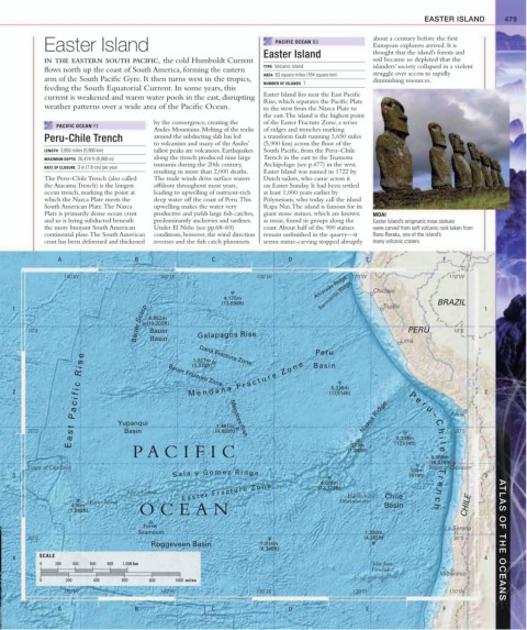
Plate is primarily dense ocean crust productive and yields large fish catches, giant stone statues, which are known MOAI
and so is being subducted beneath predominantly anchovies and sardines. as moai, found in groups along the Easter Island’s enigmatic moai statues
the more buoyant South American Under El Niño (see pp.68–69) coast. About half of the 900 statues were carved from soft volcanic rock taken from
continental plate. The South American conditions, however, the wind direction remain unfinished in the quarry—it Ranu Raraku, one of the island’s
crust has been deformed and thickened reverses and the fish catch plummets. seems statue-carving stopped abruptly many volcanic craters.
A B C D E F
150˚W 140˚W 130˚W 120˚W 110˚W
Alvarado Ridge Chiclayo
4,175m Sarmiento Ridge
(13,698ft) BRAZIL
Bauer Scarp (19,200ft)
1 Trujillo 1
5,852m
PERU
10˚S Bauer Galapagos Rise Lima 10˚S
Basin
Peru
e Dana Fracture Zone
1,027m
s (3,370ft)
i Basin
R Bauer Fracture Zone
M e n d a ñ a F r a c t u r e Z o n e
c 5,338m
fi (17,514ft)
2 2
i P e
c r
a u
P Mendoza Rise Nazca Ridge – Arica
Yupanqui C
t 1,481m
20˚S s Basin (4,859ft) h 20˚S
a 5,338m i
E 333m (17,514ft) l
P A CIFIC (1,093ft) e
8,069m
(26,474ft)
Tropic of Capricorn 188m Tropic of Capricorn
3 S a l a y G o m e z R i d g e 4,076m (619ft) r 3
T
e
Sala y Gomez E a s t e r F r a c t u r e Z o n e (13,373ft) Islas de los n
Easter Island Desventurados Chile c
476m Basin h CHILE
(1,562ft) OCEAN
Ferris
La Serena
Seamount 1,300m
30˚S (4,265ft) 30˚S ATLAS OF THE OCEANS
Roggeveen Basin 1,914m
(6,368ft)
SCALE
4 4
0 200 400 600 800 1,000 km Islas Juan
Fernández
Valparaíso
0 200 400 600 800 1000 miles
150˚W 140˚W 130˚W 120˚W 110˚W
A B C D E F