
Page 23 - GeoPRISMS_Newsletter_Spring2018_Neat
P. 23
C 175E 186E 31S
Importantly, this perspective will help to elucidate a clearer Australia
Australian Plate Kermadec Tr. . Kermadec Trench 0 50 100 150 200 35S
picture of megathrust earthquake and tsunami hazards along s tra lia km
New Zealand’s Hikurangi margin. Pacic Plate 45 mm/a
B North Island
The SHIRE Project has three principal components: Mt Taranaki
40S Hikurangi
1. Geophysical imaging: Harm van Avendonk (UT Austin) Plateau
and David Okaya (Univ. of Southern California) are leading the Alpine Fault Chatham Rise Chatham Kermadec Trench 37S
Islands
shoreline-crossing geophysical imaging investigations. Marine 35 mm/a South Island Sediment starved
seismic multi-channel reflection data (MCS) and seismic
refraction data recorded by ocean-bottom seismometers (OBSs) 49S 0 200 400 avalanche
kilometers
Ruatoria
are being used to characterize the incoming Hikurangi Plateau, A 0
PENINSULA
map the structure of the offshore accretionary prism, and Back arc extension RAUKUMARA Gisborne 1
& tectonic erosion
A TVZ 05CM-04 Poverty
document subducted sediment variations. Onshore recordings Seavalleys 39S
of offshore airgun shots, explosive shots, and local earthquakes will Mt Taranaki Hawke LR Hikurangi Subducted seamounts
Bay
determine the structure of the upper plate and properties of the Napier KR 05CM-01 Channel
deeper plate boundary zone. NIDFB A' 2 43 0
Australian Plate
2. Paleoseismology and morphotectonics: Paleoseismic and 0
geomorphic studies led by Jeff Marshall (Cal Poly Pomona) and 05CM-38
Jessica Pilarczyk (Univ. of Southern Mississippi) will collect new WAIRARAPA 2 41S
field data to supplement ongoing coastal tectonics investigations Cook Wellington Trough Frontal accretion PACIFIC
PLATE
1
conducted by collaborators at New Zealand’s GNS Science. This Strait 3 0 dominant Hikurangi Plateau
integrated data set will help resolve megathrust slip behavior over 6 Hikurangi 2 Hikurangi Axial
5
4
3
several seismic cycles, and constrain long-term coastal uplift and 5 1 Channel 0 1 Backarc domain ranges Forearc domain Hikurangi
Volcanic arc
0 D Coast Trough 0
subsidence patterns. This component of the project includes a 42 mm.yr -1
Research Experience for Undergraduates (REU) program, supervised AUSTRALIAN PACIFIC PLATE 40
PLATE
80
by Marshall, that engages US students in collaborative New Zealand Chatham Rise 300 200 100 0 km
fieldwork. 174E 176E 178E 180
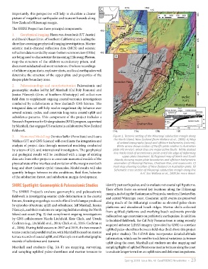
3. Numerical Modelling: Demian Saffer (Penn State) and Laura Figure 1. Tectonic setting of the Hikurangi subduction margin along
Wallace (UT and GNS Science) will coordinate the integration and the North Island, New Zealand (from Wallace et al., 2009). A) Map
of onland topography (gray) and offshore bathymetry (colored).
analysis of project data through numerical modeling conducted White arrow shows motion of Pacific plate relative to Australian
by a team of U.S. and international investigators. The geophysical plate (43 mm/yr). Black lines are major active faults. White dashed
and geological results will be combined with a range of existing line marks back of accretionary prism and front edge of deforming
upper-plate basement. B) Regional map of North and South
data sets from other projects to constrain numerical models of the Islands showing major plate boundaries and offshore bathymetric
physical state of the interface and evolution of the margin over both anomalies of Hikurangi Plateau, Chatham Rise, and seamounts. C)
long and short (seismic cycle) timescales. Model results will also Inset map showing location of New Zealand on Australian plate. D)
Schematic cross section of Hikurangi subduction margin along line
quantify linkages between in situ conditions, fluid flow, behavior A-A’. See Wallace et al., 2009 for more detail.
of the subduction thrust, and subduction margin development.
SHIRE Spotlight: Geomorphic & Paleoseismic Studies identify past earthquakes, and to evaluate net coastal uplift patterns.
Their efforts focus on several key locations along the Hikurangi
The SHIRE Project’s onshore geomorphic and paleoseismic margin, including the Raukumaura Peninsula, southern Hawkes Bay,
fieldwork is investigating seismic cycle deformation in the coastal and central Wairarapa coast. Coseismic uplift events are preserved
fore arc, focusing on geologic records of land level changes produced along much of the Hikurangi coastline as elevated paleo-shore
by episodes of tectonic uplift and subsidence. Jeff Marshall, Jessica platforms and abandoned beach ridges. Marine shells collected
Pilarczyk, and their students are targeting field sites along the North from uplifted platforms and overlying beach sediments provide
Island east coast (Fig. 2) that compliment ongoing investigations radiocarbon age constraints on prehistoric earthquakes. In addition
by GNS collaborators Nicola Litchfield, Kate Clark, and Ursula to localized fieldwork, the Cal Poly Pomona team is using recently
Cochran (e.g., Litchfield et al., 2016; Clark et al., 2015; Cochran et acquired airborne LiDAR imagery (provided by GNS) to correlate
al., 2006). During field seasons in 2017 and 2018, the two research uplifted paleo-shorelines between field sites (both from this project
teams conducted parallel studies, with Marshall focused on marine and prior studies). The LiDAR data incorporates detailed altitude
terrace records of coastal uplift, and Pilarczyk on marsh stratigraphic information, which can be used to track lateral variations in terrace
records of subsidence and tsunami. uplift along the coast. Marshall and students are also mapping and
Marshall and students (Fig. 3A-F) are mapping, surveying, sampling flights of uplifted Pleistocene marine terraces along the coast
and sampling uplifted paleo-shorelines and marine terraces to to evaluate longer-term fore arc uplift rates and deformation patterns.
Spring 2018 Issue No. 40 GeoPRISMS Newsletter • 23