
Page 110 - (DK) Ocean - The Definitive Visual Guide
P. 110
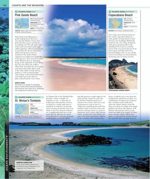
108     COASTS AND THE SEASHORE


                  ATLANTIC OCEAN WEST                                                                       ATLANTIC OCEAN SOUTHWEST
               Pink Sands Beach                                                                         Copacabana Beach

                              TYPE  Dissipative beach,                                                                 TYPE  Embayed,
                              protected by reefs                                                                       dissipative beach
                              COMPOSITION  Sand                                                                        COMPOSITION  White
                              mixed with broken shells                                                                 sand
                              and skeletons
                                                                                                                            1
                                                                                                                       LENGTH  2 / 2 miles (4 km)
                              LENGTH  2.5 miles (4 km)
               LOCATION  Harbour Island, off Eleuthera, northeast                                       LOCATION  Rio de Janeiro, southeastern Brazil
               of Nassau, Northern Bahamas
                                                                                                        One of the most famous beaches in
               Pink Sands in the Bahamas is a                                                           the world, Copacabana Beach is a
               gently sloping beach that faces                                                          wide, gently curving stretch of sand
               east onto the Atlantic Ocean. It is                                                      between two headlands. Behind the
               protected from ocean currents by                                                         beach lies the city of Rio de Janeiro,
               an outlying reef. The pale pink color                                                    with green, luxuriant hills in the
               of the sand comes from small, single-                                                    hinterland. The beach is crowded
               celled organisms called foraminiferans,                                                  much of the year and is known for its
               in particular, the species Homotrema                                                     beach sports and New Year’s Eve
               rubrum, also known as the sea                                                            firework displays. The sea area off the
               strawberry. The shells of these                                                          beach is not always recommended for
               organisms are bright red or pink due                                                     swimming, due to strong currents.
               to the presence of an iron salt. In parts
               of the Bahamas they are abundant,
               living on the underside of reefs. When
               they die, they fall to the seafloor,
               where they are broken by wave action
               and mixed with other debris, such
               as the white shells of snails and sea
               urchins, as well as mineral grains.
               This mixture is then finely pulverized
               and washed up on the shore as
               pink-colored sand by wave action.

               GENTLE SLOPE
               Pink Sands is an example of a dissipative
               beach, on which waves break some distance
               from the shore, then slowly roll in, dissipating
               their energy across a broad surf zone.                                                   COPACABANA LOOKING NORTH

                                             St. Ninian’s Isle in the Shetland Isles   typically projects at right angles to the    forms a tombolo may come from the
                  ATLANTIC OCEAN NORTHEAST
                                             provides a classic example of a   coast and has a beach on each side.    mainland, the island, the sea floor, or a
               St. Ninian’s Tombolo          tombolo, or ayre—a short spit of   St. Ninian’s Tombolo has been in   combination. Scientists have deduced
                                             sedimentary material that connects    existence for at least 1,000 years, and   that a tombolo will usually form
                              TYPE           an island to a nearby land mass or   its permanence may be due to a   when the island’s distance from the
                              Tombolo        mainland. A tombolo is formed by   cobble base underlying the sand. This   shore is less than two-thirds of its length
                              COMPOSITION     waves curving around the back of an   tombolo tends to become lower and    parallel to the shore (the distance of St.
                              Yellow and white sand  island so that they deposit sediment   narrower during storms as a result of   Ninian’s Isle from the shore is only
                              LENGTH         on a neighboring land mass, at the   destructive wave action, while during   about one third of its length). In other
                              1 / 2 mile (700 m)
                                             point directly opposite the island.   calmer weather the waves build it up   cases, a feature called a salient may
               LOCATION  West coast of southern Mainland, the    Over time, these sediments gradually   again with sand carried from offshore   form—a sand spit that extends toward
               main island of the Shetland Isles, off Scotland, UK  build up into a tombolo, which   or the nearshore. The sediment that   the island but does not quite reach it.


        OCEAN ENVIRONMENTS  NARROW CONNECTION


                 A slim, sandy tombolo extends from
                 the Shetland island of Mainland in the
                 foreground, to St. Ninian’s Isle.