Page 111 - (DK) Ocean - The Definitive Visual Guide
P. 111

109


                ATLANTIC OCEAN NORTHEAST   coast, carried by wind (sand drift)    ATLANTIC OCEAN NORTHEAST
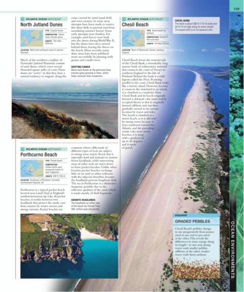
                                           and wave erosion. In some areas,                             CHESIL BANK
             North Jutland Dunes           attempts have been made to restrict   Chesil Beach           The bank is about 560 ft (170 m) wide and
                                           this dune drift, to prevent sand from                        50 ft (15 m) high along its entire length.
                           TYPE  Coastal dunes  inundating summer houses. Some         TYPE  Storm beach on   The beach (left) is on its seaward side.
                           COMPOSITION  Yellow   early attempts were fruitless. For    tombolo
                           sand, marram grass  example, sand fences were built         COMPOSITION  Gravel of
                           LENGTH  155 miles   into the dunes during World War II,     flint and chert
                           (250 km)        but the dunes have since moved              LENGTH  18 miles (29 km)
                                           behind them, leaving the fences on
             LOCATION  North and northwest coast of Jutland,   the beach. More recently, many    LOCATION  West of Weymouth, Dorset, southern
             Denmark                       dune areas have been stabilized    England
                                           more successfully by planting with
             Much of the northern coastline of   grasses and conifer trees.  Chesil Beach forms the seaward side
             Denmark’s Jutland Peninsula consists                       of the Chesil Bank, a remarkably long,
             of sand dunes, which cover several   SHIFTING SANDS        narrow bank of sedimentary material
             thousand square miles of coast. These   Many sand dunes on the peninsula have   that connects the coast of Dorset in
             dunes are “active” in that they have a   marram grass growing in them, which    southern England to the Isle of
             natural tendency to migrate along the   helps constrain their movement.  Portland. Behind the bank is a tidal
                                                                        lagoon called the Fleet. Running
                                                                        parallel to the coast, Chesil Bank looks
                                                                        like a barrier island. However, because
                                                                        it connects the mainland to an island,
                                                                        it is classified as a tombolo. How
                                                                        Chesil Bank and its beach originally
                                                                        formed is debated—the most widely
                                                                        accepted theory is that it originally
                                                                        formed offshore and was then
                                                                        gradually moved to its current
                                                                        location by waves and tides.
                                                                        The beach is classified as a
                                                                        storm beach, as it is affected
                                                                        by strong waves because it
                                                                        faces southwest toward the
                                                                        Atlantic and the prevailing
                                                                        winds. Like most storm
                                                                        beaches, it is steep,
                                                                        with a gradient of
                                                                        up to 45 degrees,
                                                                        and is made
                                           common where cliffs made of   of gravel.
                ATLANTIC OCEAN NORTHEAST
                                           different types of rock are subject
             Porthcurno Beach              to strong wave action. Rock that is
                                           especially hard and resistant to erosion
                            TYPE  Pocket beach  forms headlands, while intervening
                            COMPOSITION    areas of softer rock are worn down
                            Yellow-white sand,   to form pocket beaches. Unlike other
                            composed mainly of   beaches, pocket beaches exchange
                            shell fragments
                                           little or no sand or other sediment
                            LENGTH  500 ft (150 m)  with the adjacent shoreline, because
             LOCATION  Southwest of Penzance, Cornwall,   the headlands prevent longshore drift.
             southwestern England, UK      The sea at Porthcurno is a distinctive
                                           turquoise, possibly due to the
             Porthcurno is a typical pocket beach   reflective qualities of the sand, which
             located near Land’s End at England’s   is made mainly of shell fragments.
             southwesternmost tip. Like all pocket
             beaches, it nestles between two   GRANITE HEADLANDS
             headlands that protect the sandy cove   The headlands on either side
             from erosion by winter storms and   of the beach are formed from
             strong currents. Pocket beaches are   300- million-year-old granite.
                                                                                                        DISCOVERY
                                                                                                        GRADED PEBBLES

                                                                                                        Chesil Beach’s pebbles change
                                                                                                        in size progressively from potato-
                                                                                                        sized at one end to pea-sized
                                                                                                        at the other. This reveals the
                                                                                                        differences in wave energy along
                                                                                                        its length—at one end, strong
                                                                                                        waves wash smaller pebbles       OCEAN ENVIRONMENTS
                                                                                                        offshore; at the other, weaker
                                                                                                        waves wash them onshore.
   106   107   108   109   110   111   112   113   114   115   116