
Page 115 - (DK) Ocean - The Definitive Visual Guide
P. 115
BEACHES AND DUNES 113
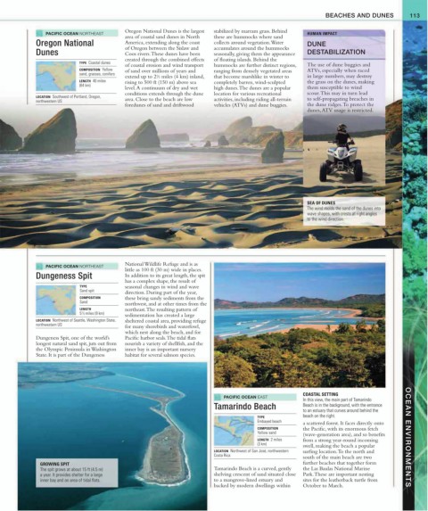
PACIFIC OCEAN NORTHEAST Oregon National Dunes is the largest stabilized by marram grass. Behind HUMAN IMPACT
area of coastal sand dunes in North these are hummocks where sand
Oregon National America, extending along the coast collects around vegetation. Water DUNE
of Oregon between the Sislaw and accumulates around the hummocks
Dunes Coos rivers. These dunes have been seasonally, giving them the appearance DESTABILIZATION
created through the combined effects of floating islands. Behind the
TYPE Coastal dunes
of coastal erosion and wind transport hummocks are further distinct regions, The use of dune buggies and
COMPOSITION Yellow of sand over millions of years and ranging from densely vegetated areas ATVs, especially when raced
sand, grasses, conifers
1
extend up to 2/2 miles (4 km) inland, that become marshlike in winter to in large numbers, may destroy
LENGTH 40 miles rising to 500 ft (150 m) above sea completely barren, wind-sculpted the grass on the dunes, making
(64 km)
level. A continuum of dry and wet high dunes. The dunes are a popular them susceptible to wind
conditions extends through the dune location for various recreational scour. This may in turn lead
LOCATION Southwest of Portland, Oregon, to self-propagating breaches in
northwestern US area. Close to the beach are low activities, including riding all-terrain
foredunes of sand and driftwood vehicles (ATVs) and dune buggies. the dune ridges. To protect the
dunes, ATV usage is restricted.
SEA OF DUNES
The wind molds the sand of the dunes into
wave shapes, with crests at right angles
to the wind direction.
PACIFIC OCEAN NORTHEAST National Wildlife Refuge and is as
little as 100 ft (30 m) wide in places.
Dungeness Spit In addition to its great length, the spit
has a complex shape, the result of
TYPE seasonal changes in wind and wave
Sand spit direction. During part of the year,
COMPOSITION these bring sandy sediments from the
Sand
northwest, and at other times from the
LENGTH northeast. The resulting pattern of
5 1 / 2 miles (9 km)
sedimentation has created a large
LOCATION Northwest of Seattle, Washington State, sheltered coastal area, providing refuge
northwestern US
for many shorebirds and waterfowl,
which nest along the beach, and for
Dungeness Spit, one of the world’s Pacific harbor seals. The tidal flats
longest natural sand spit, juts out from nourish a variety of shellfish, and the
the Olympic Peninsula in Washington inner bay is an important nursery
State. It is part of the Dungeness habitat for several salmon species.
COASTAL SETTING
PACIFIC OCEAN EAST
In this view, the main part of Tamarindo
Tamarindo Beach Beach is in the background, with the entrance
to an estuary that curves around behind the
TYPE beach on the right.
Embayed beach a scattered forest. It faces directly onto
COMPOSITION the Pacific, with its enormous fetch
Yellow sand (wave-generation area), and so benefits
LENGTH 2 miles from a strong year-round incoming OCEAN ENVIRONMENTS
(3 km) swell, making the beach a popular
LOCATION Northwest of San José, northwestern surfing location. To the north and
Costa Rica
south of the main beach are two
GROWING SPIT further beaches that together form
The spit grows at about 15 ft (4.5 m) Tamarindo Beach is a curved, gently the Las Baulas National Marine
a year. It provides shelter for a large shelving crescent of sand situated close Park. These are important nesting
inner bay and an area of tidal flats. to a mangrove-lined estuary and sites for the leatherback turtle from
backed by modern dwellings within October to March.