
Page 131 - (DK) Ocean - The Definitive Visual Guide
P. 131
129
PACIFIC OCEAN NORTHWEST PACIFIC OCEAN NORTHWEST
Saemangeum Yatsu-Higata
Wetlands Tidal Flat
TYPE TYPE
Mudflats, sandflats, and Tidal mudflat
salt marshes
AREA
AREA 1 / 6 square mile
155 square miles (0.4 square km)
(400 square km)
LOCATION South of Seoul, on the west coast of LOCATION Narashino City, at the northern part of
South Korea Tokyo Bay, Japan
Situated at the confluence of the Yatsu-Higata is a tiny rectangular
Mangyeung and Dongjin river estuaries, mudflat at the northern end of Tokyo
on South Korea’s Yellow Sea coast, the Bay, and is unusual because it is almost
Saemangeum Wetlands is a shorebird completely surrounded by a dense
staging site of great urban area. Once open shoreline,
importance. Its tidal Yatsu-Higata now sits /5 mile (1 km)
3
flats and shallows inland. Twice daily, it experiences a
support many bird tidal inflow and outflow of water from
species, some of which wetland—as well as the LOW TIDE AT DONGJIN ESTUARY Tokyo Bay via two concrete channels.
are considered to be thousands of migratory The area around the estuary consists of tidal When the tide comes in, the mudflat
globally threatened. In birds that depend on it flats and scattered salt marsh intersected by fills with about 3 ft (1 m) of water.
2010, the status of this as a key feeding area— channels that fill at high tide. When it flows out, a variety of
came under threat due resident and migrant shorebirds
SPOON-BILLED to the completion of a wetland into dry land for industrial congregate to feed on the lugworms,
SANDPIPER 22-mile- (33-km-) long or agricultural use, together with a crabs, and other marine animals that
This extremely rare species sea wall at the mouth freshwater reservoir. The project is live within the fine silt that remains.
is one of the shorebirds of the two estuaries. going ahead despite the fears of Yatsu-Higata is an important stopover
most threatened by the The sea wall is part of conservation groups that it will result point for migrating birds flying from
reclamation project. a project to turn the in irreversible environmental damage. Siberia to Australia and Southeast Asia.
Many areas on the coast of southern when it reaches the sea. Because The mudflats are dangerous for human
PACIFIC OCEAN NORTHEAST
and western Alaska are fringed by tidal ranges around Alaska are visitors, because in some areas they
Alaskan Mudflats mudflats that appear at low tide. They generally high, the total area of behave like quicksand. Even mud that
are formed of a finely ground silt that mudflats exposed at low tide is huge. at first seems firm enough to support
TYPE in some areas is several hundred yards These mudflats are an important a person may in reality be treacherous.
Tidal mudflats deep. This silt has originated from the stopover for migrating shorebirds. A number of people have become
AREA action of Alaska’s numerous glaciers, Various species of burrowing worms stuck and some have even drowned.
4,000 square miles
(10,000 square km) which have been grinding away at and bivalve mollusks are an important
the surrounding mountains for source of food for these waders and DRYING MUDFLATS
thousands of years. As these glaciers for the waterfowl that feed on the These mudflats are at the edge of a large delta
LOCATION Various coastal inlets of southern and melt, the silt is carried to the coast in mudflats through the winter. Harbor on the southwest coast of Alaska, formed by
western Alaska, US meltwater and deposited as sediment seals also use the mudflats as rest areas. the Yukon and Kuskokwim rivers.
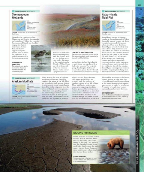
DIGGING FOR CLAMS
Brown bears are occasional visitors
to some Alaskan mudflats, where
they dig for Pacific razor clams
buried in the mud. They probably
find the clams by looking for the
small holes they leave on the surface OCEAN ENVIRONMENTS
as they burrow down. Extracting
them is tricky, since when disturbed,
they burrow down further.
ALASKAN BROWN BEAR
This large adult bear is digging on the coast
of Katmai National Park, at the eastern end
of the Alaskan Peninsula.