
Page 533 - 9780077418427.pdf
P. 533
/Users/user-f465/Desktop
tiL12214_ch20_501-520.indd Page 510 9/3/10 6:23 PM user-f465
tiL12214_ch20_501-520.indd Page 510 9/3/10 6:23 PM user-f465 /Users/user-f465/Desktop
GLACIERS
Glaciers presently cover only about 10 percent of Earth’s con-
tinental land area, and much of this is at higher latitudes, so
it might seem that glaciers would not have much of an overall
effect in eroding the land. However, ice has sculptured much of
the present landscape, and features attributed to glacial episodes
are found over about three-quarters of the continental surface.
Only a few tens of thousands of years ago, sheets of ice covered
major portions of North America, Europe, and Asia. Today, the
most extensive glaciers in the United States are those of Alaska,
which cover about 3 percent of the state’s land area. Less exten-
sive glacier ice is found in the mountainous regions of Washing-
ton, Montana, California, Colorado, and Wyoming.
A glacier is a mass of ice on land that moves under its own
weight. Glacier ice forms gradually from snow, but the quantity
of snow needed to form a glacier does not fall in a single winter.
Glaciers form in cold climates where some snow and ice persist
throughout the year. The amount of winter snowfall must exceed
the summer melting to accumulate a sufficient mass of snow to
form a glacier. As the snow accumulates, it is gradually trans-
formed into ice. The weight of the overlying snow packs it down,
driving out much of the air, and causing it to recrystallize into a
coarser, denser mass of interlocking ice crystals that appears
to have a blue to deep blue color. Complete conversion of snow
into glacial ice may take from 5 to 3,500 years, depending on
such factors as climate and rate of snow accumulation at the top
of the pile. Eventually, the mass of ice will become large enough
that it begins to flow, spreading out from the accumulated mass.
Gla ciers that form at high elevations in mountainous regions are
called alpine glaciers. If these glaciers flow down into a valley,
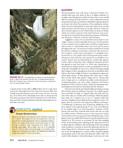
FIGURE 20.11 The waterfall and rapids on the Yellowstone they are also called valley glaciers (Figure 20.13). Glaciers that
River in Wyoming indicate that the river is actively downcutting. cover a large area of a continent are called continental glaciers.
Note the V-shaped cross-profile and lack of floodplain, characteris- Continental glaciers can cover whole continents and reach a
tics of a young stream valley.
thickness of 1 km (3,295 ft) or more. Today, the remaining conti-
nental glaciers are found on Greenland and the Antarctic.
a deposit at the mouth called a delta (Figure 20.12). Large rivers Glaciers move slowly and unpredictably, spreading as a huge
such as the Mississippi River have large and extensive deltas that blob of putty under the influence of gravity. As an alpine gla cier
actually extend the landmass more and more over time. In a way, moves downhill through a V-shaped valley, the sides and bot-
you could think of the Mississippi River delta as being formed tom of the valley are eroded wider and deeper. When the glacier
from pieces and parts of the Rocky Mountains, the Ozark Moun- later melts, the V-shaped valley is now a U-shaped valley that
tains, and other elevated landmasses that the Mississippi has car- has been straightened and deepened by the glacial erosion. The
ried there over time. glacier does its erosional work using three different techniques:
(1) bulldozing, (2) abrasion, and (3) plucking. Bulldozing, as the
term implies, is the pushing along of rocks, soil, and sediments
CONCEPTS Applied by the leading edge of an advancing glacier. Deposits of bull-
dozed rocks and other materials that remain after the ice melts
Stream Relationships are called moraines. Plucking occurs as water seeps into cracked
rocks and freezes, becoming a part of the solid glacial mass. As the
Measure and record the speed of a river or stream every day
for a month. The speed can be calculated from the time glacier moves on, it pulls the fractured rock apart and plucks away
required for a floating object to cover a measured distance. chunks of it. The process is accelerated by the frost- wedging
Define the clarity of the water by shining a beam of light action of the freezing water. Plucking at the uppermost level of
through a sample, then comparing to a beam of light an alpine glacier, combined with weathering of the surrounding
through clear water. Use a scale, such as 1 for perfectly rocks, produces a rounded or bowl-like depression known as a
clear to 10 for no light coming through, to indicate clarity. cirque (Figure 20.14). Abrasion occurs as the rock fragments fro-
Graph your findings to see if there is a relationship between zen in the moving glacial ice scratch, polish, and grind against
clarity and speed of flow of the stream. surrounding rocks at the base and along the valley walls. The
result of this abrasion is the pulverizing of rock into ever finer
510 CHAPTER 20 Shaping Earth’s Surface 20-10