
Page 17 - GeoPRISMS_Newsletter_Spring2018_Neat
P. 17
the complete succession of incoming sedimentary and volcanic Building on that background, JOIDES Resolution drilled along the
strata on the subducting Hikurangi Plateau (a Cretaceous large north Hikurangi transect to address three main goals:
igneous province) including the overlying trench-wedge in the 1. Documentation of the state and composition of the incoming
Hikurangi Trough (Sites U1520 and U1526) (Fig. 2). Detailed thrust- plate (sedimentary and volcanic rocks), as well as the shallow plate-
sequence analysis via core-log-seismic integration will continue boundary fault near the trench; these rocks comprise the protolith
post-expedition. In addition to the coring program, borehole and capture initial conditions for fault-zone rocks at greater depth,
observatories were installed at Sites U1518 and U1519 to monitor which can then be extrapolated to zones that host SSEs;
in situ changes of fluid pressure, temperature, fluid-flow rate, and
fluid geochemistry in the near-field of the SSEs. 2. Quantification of material properties, thermal regime, and
stress conditions in the upper plate above the SSE source region; and
Leg 181 of the Ocean Drilling Program had cored the eastern edge
of the Hikurangi Plateau in 1998, largely for paleoceanographic 3. Direct measurements of temporal variations in deformation,
studies (Davy et al., 2008), but those sites are positioned ~600–900 temperature, and fluid flow using borehole observatories in the
km seaward of the North Island. Many uncertainties remain with near-field of the SSEs.
respect to correlative stratigraphic successions currently entering Results from a recent seafloor geodetic experiment near the IODP
the trench, as well as their potential influence on SSEs. Several transect raise the strong possibility of SSE propagation all the way to
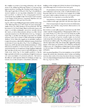
seamounts are present near the deformation front (e.g., Tūranganui the trench (Wallace et al., 2016). Site U1518 lies within the possible
Knoll) (Fig. 1), and they may also play an important, but currently SSE rupture area (Fig. 1); comprehensive post-expedition analyses
unknown, role in the occurrence of SSEs and tsunami earthquakes of those core samples will provide valuable insights into the fault
(Bell et al., 2014). Where the megathrust extends farther landward, zone’s composition, physical properties, hydrogeology, and structural
it appears to separate a relatively less-deformed sequence below from architecture at multiple scales. The drilling transect also coincides
an imbricated thrust wedge above (Fig. 2). Near the drilling transect, with the region where SSEs were dynamically triggered by passing
Barker et al. (2009) showed that the subduction interface 15–40 km seismic waves from the November, 2016, Kaikōura earthquake
inboard of the trench lies <5–6 km below the seafloor. That interface (Wallace et al., 2017). Expedition scientists expect to shed new light
seems to follow the top of a thick zone of high-amplitude reflectivity on why such large-scale SSEs were triggered by a distant (>600 km)
that coincides with the source areas of some SSEs (Bell et al., 2010; earthquake.
Pecher et al., 2018) (Fig. 2). One testable possibility is that the LWD data from Expedition 372 include resistivity-at-the-bit (RAB)
high-amplitude reflectivity is a manifestation of high fluid pressures images that provide key information about fracture and faulting
and underconsolidation of subducted sediments. Alternatively, patterns; those studies will evaluate the relation between fractured
the reflectors could represent distinctive lithologic packages (e.g., intervals and potential geochemical and/or thermal evidence of fluid
tectonic slices of altered basalt or volcaniclastic sediments). flow (e.g., Kopf et al., 2003).
25° 178°30'E 179°
S Fiji Basin 38°30'
30° Kermadec Trench 150 0 4 8 12 16 20 km S
N
Australian 100
35° Plate 100
U1519
50 mm/y
New 50 200
40° Zealand Hikurangi
Plateau
Alpine Tuaheni U1518
fault Chatham Rise U1517 Ridge Tūranganui
45° Knoll
39 mm/y
150 U1520
Paritu 39°
50° Campbell Basin
Plateau U1526
Pacic Poverty Trough
55° Plate Canyon
500 km Hikurangi
160°E 165° 170° 175° 180° 175° 170°W Channel
Figure 1. Index maps of the Hikurangi study area offshore New
Zealand. Enlarged map shows locations of IODP drilling sites and Hikurangi
contours of slip associated with recent slow-slip events identified
by Wallace et al. (2016) using offshore geodetic data.
Spring 2018 Issue No. 40 GeoPRISMS Newsletter • 17