
Page 34 - (DK) Eyewitness - Mars
P. 34
Martian highs and lows
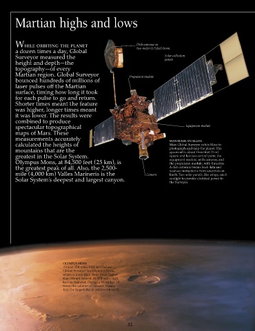
While orbiting the planet Dish antenna on
a dozen times a day, Global two-meter (6.5 feet) boom
Surveyor measured the Solar-collection
height and depth—the panels
topography—of every
Martian region. Global Surveyor Propulsion module
bounced hundreds of millions of
laser pulses off the Martian
surface, timing how long it took
for each pulse to go and return.
Shorter times meant the feature
was higher, longer times meant
it was lower. The results were
combined to produce
spectacular topographical Equipment module
maps of Mars. These
measurements accurately MAN-MADE SATELLITE
calculated the heights of Mars Global Surveyor orbits Mars to
mountains that are the photograph and map the planet. The
spacecraft is about three feet (1 m)
greatest in the Solar System. square and has two central parts: the
Olympus Mons, at 84,500 feet (25 km), is equipment module, with cameras, and
the propulsion module, with thrusters.
the greatest peak of all. Also, the 2,500- A dish antenna beams back data and
mile (4,000 km) Valles Marineris is the Camera receives instructions from scientists on
Earth. Two solar panels, like wings, catch
Solar System’s deepest and largest canyon. sunlight to provide electrical power to
the Surveyor.
OLYMPUS MONS
Almost 250 miles (402 km) below
Global Surveyer lies Olympus Mons,
which is more than three times higher
than Mount Everest. At 374 miles (624
km) in diameter, Olympus Mons has 10
times the volume of Hawaii’s Mauna
Kea, the largest shield volcano on earth.
32