Page 35 - (DK) Eyewitness - Mars
P. 35

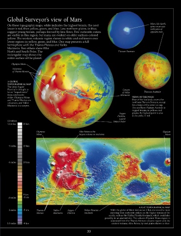
Global Surveyor’s view of Mars

      On these topographic maps, white indicates the highest terrain, the next                         Mars, like Earth,
                                                                                                       spins on an axis
      lower is red, then yellow, green, and blue. Low northern plains, in blue,                        with poles at
      suggest young terrain, perhaps formed by lava flows. Few meteorite craters                       opposite ends
      are visible in this region, but many are evident on older surfaces colored
      yellow. The western volcanic region shown in white and red towers over
      lower regions in yellow, green, and blue. One map presents a full
      hemisphere with the Tharsis Plateau and Valles
      Marineris. Two others show 0the
      North and South Poles. The                                                 Planum Boreum
      rectangular map shows the
      entire surface of the planet.
         Olympus Mons
         Volcanoes
         of Tharsis Montes


      A GLOBAL
      TOPOGRAPHICAL MAP
      The deep Argyre
      Planitia is thought to                                                        Canyon
      be an “impact crater”                                                         of Valles     Planum Australe
      from a meteorite                                                            Marineris
      strike. Olympus Mons                                                                VIEWS OF THE POLES
      and Tharsis Montes are                                                              Blue of the lowlands covers the
      volcanoes, and Valles                                                               northern Planum Boreum, except
      Marineris is a canyon.                                                              for a bulge at the polar ice cap.
                                                                                          The southern Planum Australe is
                                                                                          rugged terrain, in yellows and
                                                                                  Argyre   greens. Its highest point is also
                                                                                Planitia,   at the pole, in red.
                                                                                  a giant
      Elevation                                                               impact crater
      13 miles  21 km

                          Olympus                     Alba Patera is the                                       Elysium
                          Mons                        largest volcano in total area                              Mons


       9 miles   15 km


       6 miles   10 km


                 0 km
       .6 miles  -1 km


                                                                                               A FLAT TOPOGRAPHICAL MAP
       3 miles   -5 km    Tharsis    Valles    Argyre     Hellas Planitia   With the globe of Mars laid out as if flat, one sees the most
                          Montes     Marineris  Planitia  lowlands          cratering from meteorite strikes on the higher terrain of the
                                                                           south, such as the Hellas Planitia lowlands, which could also
                                                                        possibly be an ancient lake. The volcanic Elysium Mons region is
                                                                            separated from the Tharsis Montes volcanic region and the
      5.5 miles  -9 km                                                       ancient volcano, Alba Patera, by vast plains shown in blue.

                                                            33
   30   31   32   33   34   35   36   37   38   39   40