
Page 33 - (DK) Eyewitness - Mars
P. 33
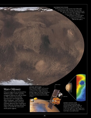
MAP PROJECTION OF MARS
                                                                           NASA teams produced this mosaic map of Mars from
                                                                               Global Surveyor data. The map uses more than
                                                                                  200 million Laser Altimeter measurements and
                                                                                     almost a thousand wide-angle Mars Orbiter
                                                                                        Camera images. The Altimeter
                                                                                           measurements show detail that is
                                                                                              not visible in photographic
                                                                                                images because of the dusty
                                                                                                  Martian atmosphere.


                                                                           Solar array

                                         ODYSSEY ABOVE MARS
      Mars Odyssey                       Mars Odyssey weighed 1,671 pounds
                                         (758 kg), fueled, and carried science
                                         instruments. This orbiter studied the
      Odyssey mapped and analyzed the    Martian surface and climate and looked
      Martian surface. NASA specially    for water. Odyssey also relayed data
      equipped Odyssey to look for water   transmissions from surface rovers back
      ice. The orbiter’s Gamma Ray       to Earth.                                    Antenna
      Spectrometer was designed to
      detect hydrogen—and therefore
      water, which contains hydrogen.
      Odyssey advanced the mapping of        Gamma Ray                                ODYSSEY MAPPING MARS
      Mars while also finding subsurface     Spectrometer                             This thermal infrared image was
                                                                                      acquired as Mars Odyssey orbited at
      water ice at both the north and                                                 13,600 miles (22,000 km) high. The
      south polar regions.                                                            1,120-mile (1,800 km) wide Argyre basin
                                                                                      can be seen. The image spans 3,900 miles
                                                                                      (6,276 km), from limb to limb.

                                                            31