
Page 116 - (DK) Ocean - The Definitive Visual Guide
P. 116
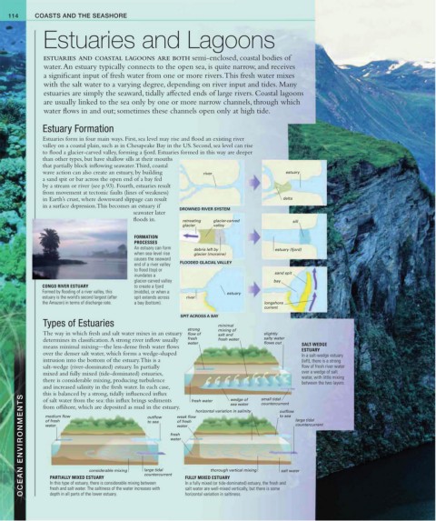
114     COASTS AND THE SEASHORE


               Estuaries and Lagoons


               ESTUARIES AND COASTAL LAGOONS ARE BOTH semi-enclosed, coastal bodies of
               water. An estuary typically connects to the open sea, is quite narrow, and receives
               a significant input of fresh water from one or more rivers. This fresh water mixes
               with the salt water to a varying degree, depending on river input and tides. Many
               estuaries are simply the seaward, tidally affected ends of large rivers. Coastal lagoons
               are usually linked to the sea only by one or more narrow channels, through which
               water flows in and out; sometimes these channels open only at high tide.


               Estuary Formation
               Estuaries form in four main ways. First, sea level may rise and flood an existing river
               valley on a coastal plain, such as in Chesapeake Bay in the US. Second, sea level can rise
               to flood a glacier-carved valley, forming a fjord. Estuaries formed in this way are deeper
               than other types, but have shallow sills at their mouths
               that partially block inflowing seawater. Third, coastal
               wave action can also create an estuary, by building    river                    estuary
               a sand spit or bar across the open end of a bay fed
               by a stream or river (see p.93). Fourth, estuaries result
               from movement at tectonic faults (lines of weakness)
               in Earth’s crust, where downward slippage can result                           delta
               in a surface depression. This becomes an estuary if
                                             seawater later   DROWNED RIVER SYSTEM
                                             floods in.      retreating   glacier-carved         sill
                                                             glacier   valley
                                             FORMATION
                                             PROCESSES
                                             An estuary can form
                                                                 debris left by            estuary (fjord)
                                             when sea-level rise   glacier (moraine)
                                             causes the seaward
                                             end of a river valley   FLOODED GLACIAL VALLEY
                                             to flood (top) or
                                                                                           sand spit
                                             inundates a
                                             glacier-carved valley                         bay
               CONGO RIVER ESTUARY           to create a fjord
               Formed by flooding of a river valley, this   (middle), or when a   estuary
               estuary is the world’s second largest (after    spit extends across   river
               the Amazon) in terms of discharge rate.  a bay (bottom).                 longshore
                                                                                        current
                                                            SPIT ACROSS A BAY
               Types of Estuaries                                       minimal
                                                              strong    mixing of
               The way in which fresh and salt water mixes in an estuary   flow of   salt and   slightly
               determines its classification. A strong river inflow usually   fresh   fresh water  salty water
                                                              water                    flows out     SALT-WEDGE
               means minimal mixing—the less-dense fresh water flows                                ESTUARY
               over the denser salt water, which forms a wedge-shaped                               In a salt-wedge estuary
               intrusion into the bottom of the estuary. This is a                                  (left), there is a strong
               salt-wedge (river-dominated) estuary. In partially                                   flow of fresh river water
               mixed and fully mixed (tide-dominated) estuaries,                                    over a wedge of salt
               there is considerable mixing, producing turbulence                                   water, with little mixing
                                                                                                    between the two layers.
               and increased salinity in the fresh water. In each case,
               this is balanced by a strong, tidally influenced influx   weak flow  horizontal variation in salinity  small tidal  outflow
        OCEAN ENVIRONMENTS  of fresh   considerable mixing  large tidal   fresh   FULLY MIXED ESTUARY  salt water
               of salt water from the sea: this influx brings sediments
                                                                            wedge of
                                                                fresh water
                                                                                       countercurrent
                                                                            sea water
               from offshore, which are deposited as mud in the estuary.
                                                                                             to sea
                medium flow
                                                 outflow
                                                                                                  large tidal
                                                           of fresh
                                                 to sea
                                                                                                  countercurrent
                                                           water
                water
                                                         water
                                                                      thorough vertical mixing
                                                countercurrent
                 PARTIALLY MIXED ESTUARY
                 In this type of estuary, there is considerable mixing between
                                                              In a fully mixed (or tide-dominated) estuary, the fresh and
                 fresh and salt water. The saltiness of the water increases with
                                                              salt water are well-mixed vertically, but there is some
                                                              horizontal variation in saltiness.
                 depth in all parts of the lower estuary.