
Page 436 - 9780077418427.pdf
P. 436
/Users/user-f465/Desktop
tiL12214_ch16_405-432.indd Page 413 9/3/10 6:19 PM user-f465
tiL12214_ch16_405-432.indd Page 413 9/3/10 6:19 PM user-f465 /Users/user-f465/Desktop
Summer solstice Winter solstice however, several different ways to describe the day, month, and
year, and each depends on a different set of events. These events
Arctic 23.5° are described in the following section.
Circle
Tropic of
Cancer Daily Time
Equator The technique of using astronomical motions for keeping time
Tropic of Surface of the Sun originated some 4,000 years ago with the Babylonian culture.
Capricorn The Babylonians marked the yearly journey of the Sun against
the background of the stars, which was divided into 12 periods,
Antarctic or months, after the signs of the zodiac. Based on this system,
Circle
the Babylonian year was divided into 12 months with a total of
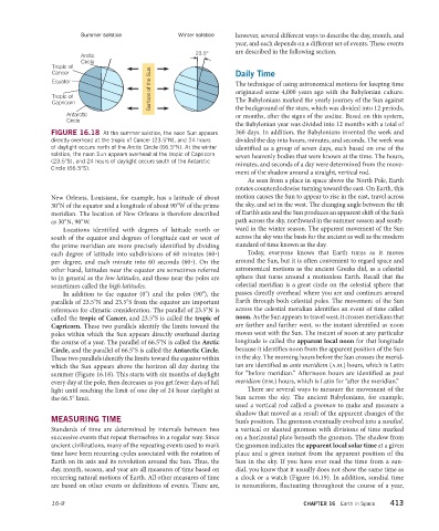
FIGURE 16.18 At the summer solstice, the noon Sun appears 360 days. In addition, the Babylonians invented the week and
directly overhead at the tropic of Cancer (23.5°N), and 24 hours divided the day into hours, minutes, and seconds. The week was
of daylight occurs north of the Arctic Circle (66.5°N). At the winter identified as a group of seven days, each based on one of the
solstice, the noon Sun appears overhead at the tropic of Capricorn seven heavenly bodies that were known at the time. The hours,
(23.5°S), and 24 hours of daylight occurs south of the Antarctic
minutes, and seconds of a day were determined from the move-
Circle (66.5°S).
ment of the shadow around a straight, vertical rod.
As seen from a place in space above the North Pole, Earth
rotates counterclockwise turning toward the east. On Earth, this
New Orleans, Louisiana, for example, has a latitude of about motion causes the Sun to appear to rise in the east, travel across
30°N of the equator and a longitude of about 90°W of the prime the sky, and set in the west. The changing angle between the tilt
meridian. The location of New Orleans is therefore described of Earth’s axis and the Sun produces an apparent shift of the Sun’s
as 30°N, 90°W. path across the sky, northward in the summer season and south-
Locations identified with degrees of latitude north or ward in the winter season. The apparent movement of the Sun
south of the equator and degrees of longitude east or west of across the sky was the basis for the ancient as well as the modern
the prime meridian are more precisely identified by dividing standard of time known as the day.
each degree of latitude into subdivisions of 60 minutes (60∙) Today, everyone knows that Earth turns as it moves
per degree, and each minute into 60 seconds (60∙). On the around the Sun, but it is often convenient to regard space and
other hand, latitudes near the equator are sometimes referred astronomical motions as the ancient Greeks did, as a celestial
to in general as the low latitudes, and those near the poles are sphere that turns around a motionless Earth. Recall that the
sometimes called the high latitudes. celestial meridian is a great circle on the celestial sphere that
In addition to the equator (0°) and the poles (90°), the passes directly overhead where you are and continues around
parallels of 23.5°N and 23.5°S from the equator are important Earth through both celestial poles. The movement of the Sun
references for climatic consideration. The parallel of 23.5°N is across the celestial meridian identifies an event of time called
called the tropic of Cancer, and 23.5°S is called the tropic of noon. As the Sun appears to travel west, it crosses meridians that
Capricorn. These two parallels identify the limits toward the are farther and farther west, so the instant identified as noon
poles within which the Sun appears directly overhead during moves west with the Sun. The instant of noon at any particular
the course of a year. The parallel of 66.5°N is called the Arctic longitude is called the apparent local noon for that longitude
Circle, and the parallel of 66.5°S is called the Antarctic Circle. because it identifies noon from the apparent position of the Sun
These two parallels identify the limits toward the equator within in the sky. The morning hours before the Sun crosses the merid-
which the Sun appears above the horizon all day during the ian are identified as ante meridiem (a.m.) hours, which is Latin
summer (Figure 16.18). This starts with six months of daylight for “before meridian.” Afternoon hours are identified as post
every day at the pole, then decreases as you get fewer days of full meridiem (p.m.) hours, which is Latin for “after the meridian.”
light until reaching the limit of one day of 24 hour daylight at There are several ways to measure the movement of the
the 66.5° limit. Sun across the sky. The ancient Babylonians, for example,
used a vertical rod called a gnomon to make and measure a
shadow that moved as a result of the apparent changes of the
MEASURING TIME Sun’s position. The gnomon eventually evolved into a sundial,
Standards of time are determined by intervals between two a vertical or slanted gnomon with divisions of time marked
successive events that repeat themselves in a regular way. Since on a horizontal plate beneath the gnomon. The shadow from
ancient civilizations, many of the repeating events used to mark the gnomon indicates the apparent local solar time at a given
time have been recurring cycles associated with the rotation of place and a given instant from the apparent position of the
Earth on its axis and its revolution around the Sun. Thus, the Sun in the sky. If you have ever read the time from a sun-
day, month, season, and year are all measures of time based on dial, you know that it usually does not show the same time as
recurring natural motions of Earth. All other measures of time a clock or a watch (Figure 16.19). In addition, sundial time
are based on other events or definitions of events. There are, is nonuniform, fluctuating throughout the course of a year,
16-9 CHAPTER 16 Earth in Space 413