
Page 575 - 9780077418427.pdf
P. 575
/Volume/201/MHDQ233/tat78194_disk1of1/0073378194/tat78194_pagefile
tiL12214_ch22_541-564.indd Page 552 9/23/10 11:08 AM user-f465
tiL12214_ch22_541-564.indd Page 552 9/23/10 11:08 AM user-f465 /Volume/201/MHDQ233/tat78194_disk1of1/0073378194/tat78194_pagefiles
Less direct
sunlight
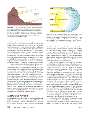
Incoming solar radiation Most direct sunlight
FIGURE 22.11 Incoming solar radiation falls more directly on
the side of a mountain, which results in differential heating. The Less direct
same amount of sunlight falls on the areas shown in this illustra- sunlight
tion, with the valley floor receiving a more spread-out distribution
of energy per unit area. The overall result is an upslope mountain FIGURE 22.12 On a global, yearly basis, the equatorial region
breeze during the day. During the night, dense, cool air flows
downslope for a reverse wind pattern. of Earth receives more direct incoming solar radiation than the
higher latitudes. As a result, average temperatures are higher in the
equatorial region and decrease with latitude toward both poles. This
sets the stage for worldwide patterns of prevailing winds, high and
Another pattern of local winds develops in mountainous low areas of atmospheric pressure, and climatic patterns.
regions. If you have ever visited a mountain in the summer, you
may have noticed that there is usually a breeze or wind blowing
up the mountain slope during the afternoon. This wind pattern when the records for a long period of time are analyzed. These
develops because the air over the mountain slope is heated more records show that Earth has a large-scale pattern of atmospheric
than the air in a valley. As shown in Figure 22.11, the air over the circulation that varies with latitude. There are belts in which the
slope becomes warmer because it receives more direct sunlight winds average an overall circulation in one direction, belts of
than the valley floor. Sometimes this air movement is so gentle higher atmospheric pressure averages, and belts of lower atmo-
that it would be unknown except for the evidence of clouds that spheric pressure averages. This has led to a generalized pattern
form over the peaks during the day and evaporate at night. During of atmospheric circulation and a global atmospheric model.
the night, the air on the slope cools as the land loses radiant energy This model, as you will see, today provides the basis for the daily
to space. As the air cools, it becomes denser and flows downslope, weather forecast for local and regional areas.
forming a reverse wind pattern to the one observed during the day. As with local wind patterns, it is temperature imbalances
During cooler seasons, cold, dense air may collect in valleys that drive the global circulation of the atmosphere. Earth receives
or over plateaus, forming a layer or “puddle” of cold air. Such an more direct solar radiation in the equatorial region than it does
accumulation of cold air often results in some very cold night- at higher latitudes (Figure 22.12). As a result, the temperatures
time temperatures for cities located in valleys, temperatures that of the lower troposphere are generally higher in the equatorial
are much colder than anywhere in the surrounding region. Some region, decreasing with latitude toward both poles. The lower
weather disturbance, such as an approaching front, can disturb troposphere from 10°N to 10°S of the equator is heated, ex-
such an accumulation of cold air and cause it to pour out of its pands, and becomes less dense. Hot air rises in this belt around
resting place and through canyons or lower valleys. Air moving the equator, known as the intertropical convergence zone. The
from a higher altitude like this becomes compressed as it moves rising air cools because it expands as it rises, resulting in heavy
to lower elevations under increasing atmospheric pressure. average precipitation. The tropical rainforests of Earth occur in
Compression of air increases the temperature by in creasing the this zone of high temperatures and heavy rainfall. As the now
kinetic energy of the molecules. This creates a wind called a dry, rising air reaches the upper parts of the troposphere, it
Chinook, which is common to mountainous and adjacent re- begins to spread toward the north and toward the south, sink-
gions. A Chinook is a wind of compressed air with sharp tem- ing back toward Earth’s surface (Figure 22.13). The descending
perature increases that can sublimate or melt away any existing air reaches the surface to form a high-pressure belt that is cen-
snow cover in a single day. The Santa Ana is a well-known com- tered about 30°N and 30°S of the equator. Air moving on the
pressional wind that occurs in southern California. surface away from this high-pressure belt produces the prevail-
ing northeast trade winds and the prevailing westerly winds of
the Northern Hemisphere. The great deserts of Earth are also
GLOBAL WIND PATTERNS located in this high-pressure belt of descending dry air.
Local wind patterns tend to mask the existence of the overall Poleward of the belt of high pressure, the atmospheric circu-
global wind pattern that is also present. The global wind pat- lation is controlled by a powerful belt of wind near the top of the
tern is not apparent if the winds are observed and measured troposphere called a jet stream. Jet streams are meandering loops
for a particular day, week, or month. It does become apparent of winds that tend to extend all the way around Earth, moving
552 CHAPTER 22 The Atmosphere of Earth 22-12