
Page 21 - (DK) Eyewitness - Mars
P. 21
Mariner 9: first to orbit Mars POLAR ICE CAP
After several weeks, the dust storm
passed, revealing enormous
canyon networks—termed
“chasmas”—and soaring
volcanoes. Earlier Mariners had
missed the most magnificent
Martian topography, including
the northern polar cap. It is about
625 miles (1,000 km) across.
THE VALLEYS OF MARINER
Mariner 9 data allowed mapmakers to chart Martian
topography, such as the channel above, which
NASA scientists named Mangala Vallis. “Mangala”
is the ancient Sanskrit word for Mars. NASA began
naming the many newfound Martian features. They
called the largest canyon system Valles Marineris, in
honor of the Mariner missions.
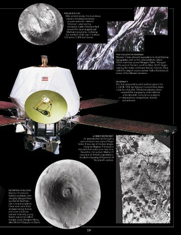
MARINER
The first spacecraft to orbit another planet, the
1,116-lb. (506 kg) Mariner 9 circled Mars twice
a day for a full year. Television cameras photo-
mapped the topography while infrared
and ultraviolet instruments analyzed
atmospheric composition, density,
and pressure.
A DRIED RIVER BED?
An ancient channel through a
cratered desert was named Nirgal
Valles. It was one of the key images
taken by Mariner 9 because it
indicated that water once may have
flowed on the surface. Mariner 9
exceeded all NASA’s expectations
by photo-mapping 100 percent of
the planet’s surface.
OLYMPIAN VOLCANO
Mariner 9’s pictures
thrilled scientists, who
abruptly changed their
past belief that Mars
was a long-dead planet.
There were even hints
of water having flowed,
and some volcanoes
seemed relatively young.
NASA named the tallest
volcanic peak Olympus Mons,
after Mount Olympus on Earth.
1