
Page 119 - (DK) Ocean - The Definitive Visual Guide
P. 119
117
ATLANTIC OCEAN WEST similarly cut off by a string of barrier ATLANTIC OCEAN SOUTHWEST sediments driven by tidal action and
islands. The entire lagoon connects winds. The salinity of the lagoon
Laguna Madre with the Gulf only via a few narrow Lagoa dos Patos varies. It consists mainly of fresh water
channels, and it is less than 3 ft (1 m) at times of high rainfall, but there is
TYPE deep in most parts. It is saltier than TYPE considerable saltwater intrusion at its
Hypersaline coastal Tidal coastal lagoon
lagoon seawater because it receives no input southern end at times of drought.
of river water and lies in a hot, dry AREA Lagoa dos Patos is one of Brazil’s most
AREA 3,900 square miles
14,400 square miles region, leading to high rates of (10,000 square km) vital fishing grounds. However,
(3,660 square km) evaporation. Seagrass meadows and run-off from rice fields and
several species of crustaceans and pastureland, industrial effluents, and
LOCATION Southern Texas, US, and northeastern fish thrive in the lagoon, which also LOCATION South of the city of Porto Alegre, southern increasing population have led to
Mexico, along the coast of the Gulf of Mexico supports many wintering shorebirds Brazil concerns for the lagoon’s ecosystem.
and waterfowl. Threats to the lagoon’s
The Laguna Madre is a shallow lagoon health include dredging, overfishing, Lagoa dos Patos (“Lagoon of Ducks”)
in two distinct parts extending about and algal blooms. is the world’s largest coastal lagoon.
285 miles (456 km) along the coast of Its name is said to have been given to
the Gulf of Mexico. Its northern part, FLY-FISHING FOR REDFISH it by Jesuit settlers in the 16th century,
in Texas, is separated from the Gulf by The sale of licenses for fly-fishing—for trout who bred waterfowl on its shores. It is
a long, thin barrier island, Padre Island. and redfish—in the Laguna provides funds for a shallow, tidal body of water, 155 miles
The southern part, in Mexico, is protecting its water quality and wildlife. (250 km) long and up to 35 miles
(56 km) wide. A sand bar separates
it from the Atlantic, with which it
connects at its southern end via a
short, narrow channel that disgorges a
large plume of sediment into the ocean.
Marine animals use this channel to
access the lagoon; sea turtles are found
in the lagoon in spring and summer.
At its northern end, the lagoon
receives an inflow of fresh water from
the Guaíba Estuary, formed from the
confluence of the Rio Jacui and three OCEAN ENVIRONMENTS
smaller rivers. Along its inner side are
a number of distinctive wavelike
“cusps” that have been caused by the
accumulation and erosion of
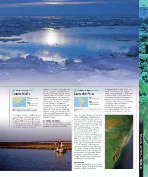
TWO LAGOONS
In this aerial view, Lagoa dos Patos is the pale
central area. Below it, the darker Mirim Lagoon
extends to the Brazil–Uruguay border.