
Page 120 - (DK) Ocean - The Definitive Visual Guide
P. 120
118 COASTS AND THE SEASHORE
ATLANTIC OCEAN SOUTHWEST
Amazon Estuary
TYPE Salt-wedge
(river-dominated) estuary
AREA Approximately
7,800 square miles
(20,000 square km)
LOCATION Northern Brazil
HUMAN IMPACT
The Amazon Estuary is a stretch of
the Amazon River that extends more POROROCA SURF
than 190 miles (300 km) inland from
the river’s mouth to an area southwest Tidal bores, locally called pororocas,
of the city of Macapà. Varying in width occur on large spring tides in
from 15 to 190 miles (25 to 300 km), several of northern Brazil’s river
the estuary is partly filled by numerous estuaries. Some of these bores
low-lying, forested islands. attain heights of 10 ft (3 m) and
The Amazon Estuary has by far the can be surfed for several miles.
largest water output of any estuary in This sport is rather hazardous,
the world, discharging an average of however, because the waters
45 million gallons (200 million liters) through which the pororocas surge
per second into the Atlantic. The sheer are home to dangerous snakes,
magnitude of this discharge means fish, and crocodiles.
that, almost uniquely among estuaries,
there is very little saltwater intrusion
into it. Instead, nearly all of the mixing
between the river’s discharge and
seawater occurs outside the estuary, on
an area of continental shelf. Despite
the relative lack of seawater intrusion,
the whole estuary is significantly
affected by twice-daily tides, which
cause inundation (by river water) of
most of the islands in the estuary.
MARAJO ISLAND
The Amazon Estuary is so enormous that the
biggest of the forested islands lying within
it, Marajo Island, has its own river system.
ATLANTIC OCEAN SOUTHWEST The Plate River, or Rio de la Plata, is vast amount of water, the estuary varies uniformly through the estuary,
not a river but a large, funnel-shaped receives about 2 billion cubic feet from close to zero in its upper parts
River Plate estuary formed by the confluence of (57 million cubic meters) of silt each to a value just below average ocean
the rivers Uruguay and Paraná. These year from its input rivers. This mud salinity near its mouth. Deep down,
TYPE rivers and their tributaries drain about accumulates in great shoals, so that the a wedge of salt water penetrates deep
Salt-wedge
(river-dominated) estuary one-fifth of the land area of South water depth in most of the estuary is into the estuary. Biologically, the Plate
America. At 180 miles (290 km) long less than 10 ft (3 m). Constant dredging is highly productive, yielding large
AREA
13,500 square miles and 136 miles (220 km) wide at its is therefore needed to maintain annual masses of plankton, which
(35,000 square km) mouth, the Plate discharges about deep-water channels to the ports of support large numbers of fish and dense
6.5 million gallons (25 million liters) Buenos Aires, which lies near the head beds of clams. It is also a habitat for
LOCATION On the Argentina–Uruguay border, east of of water per second into the Atlantic of the estuary, and Montevideo, which the La Plata Dolphin, an endangered
Buenos Aires and southwest of Montevideo Ocean. As well as transporting this is close to its mouth. Surface salinity long-beaked species of river dolphin.
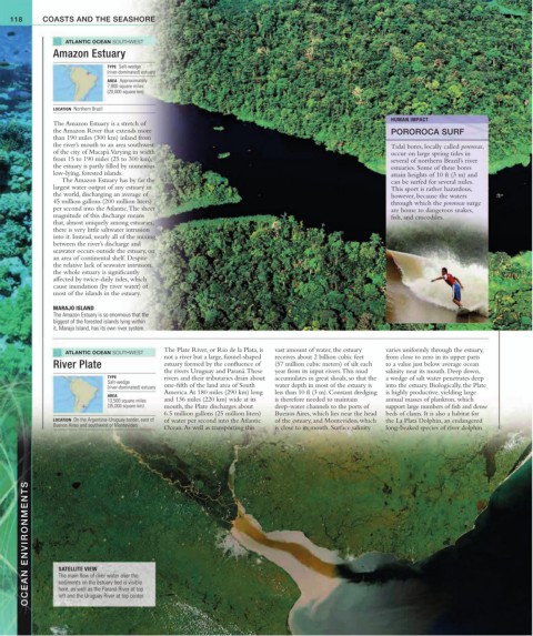
OCEAN ENVIRONMENTS SATELLITE VIEW
The main flow of river water over the
sediments on the estuary bed is visible
here, as well as the Paraná River at top
left and the Uruguay River at top center.