
Page 121 - (DK) Ocean - The Definitive Visual Guide
P. 121
119
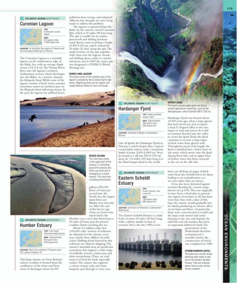
ATLANTIC OCEAN NORTHEAST pollution from sewage and industrial
effluents, but attempts are now being
Curonian Lagoon made to address this problem.
The lagoon is separated from the
TYPE Baltic by the narrow, curved Curonian
Freshwater coastal
lagoon Spit, which is 60 miles (98 km) long.
The spit is notable for its mature
AREA
610 square miles pinewoods and drifting barchans
(1,580 square km) (sand dunes), some reaching a height
of 200 ft (60 m), which extend for
LOCATION On the Baltic Sea coasts of Lithuania and 20 miles (31 km) along the spit. The
the Kaliningrad Oblast (part of Russia)
sandy beaches on the spit, together
with vistas over the lagoon, woods,
The Curonian Lagoon is a nontidal and drifting dunes, make it a tourist
lagoon on the southeastern edge of attraction, and in 2000 the entire spit
the Baltic Sea, with an average depth was designated a UNESCO World
of just 12 ft (3.8 m). The Neman River Heritage site.
flows into the lagoon’s northern
(Lithuanian) section, which discharges DUNES AND LAGOON
into the Baltic via a narrow channel, This quiet corner of the northern part of the
the Klaipeda Strait. While most of the lagoon is backed by the Curonian Spit’s high
lagoon consists of fresh water, seawater dunes. Migrating birds use the lagoon and
sometimes enters its northern part via nearby Neman Delta for vital rest breaks.
the Klaipeda Strait following storms. In
the past, the lagoon has suffered heavy
ATLANTIC OCEAN NORTHEAST UPPER FJORD
The fjord’s narrow upper parts are fed by
Hardanger Fjord several spectacular waterfalls, such as the
Vøringsfossen, which freefalls 600 ft (182 m).
TYPE Highly stratified
estuary; fjord Hardanger Fjord was formed about
AREA Approximately 10,000 years ago, when a large glacier
290 square miles that had carved out and occupied
(700 square km)
a deep U-shaped valley in the area
began to melt and retreat. As it did
LOCATION Southeast of Bergen, southwestern so, seawater flooded into the valley
Norway
to create the fjord. Today, the fjord
continues to receive a large input
Like all fjords, the Hardanger Fjord in of fresh water from glacier melt.
Norway is much deeper than a typical Throughout much of its length, the
coastal-plain estuary, with a maximum fjord is stratified into a lower layer of
depth of some 2,600 ft (800 m). Near salt water, which moves into the fjord
READS ISLAND its mouth is a sill just 500 ft (150 m) during flood tide, and an upper layer
This low-lying island, deep. At 114 miles (183 km) long, it is of fresher water that flows outward
in the upper part of the the third-longest fjord in the world. to the sea on the ebb tide.
estuary, is a breeding
ground for avocets and
other rare birds and is been cut off from its input of fresh
managed as a nature ATLANTIC OCEAN NORTHEAST water from the Scheldt River by dams,
reserve. The view here leading to its reclassification as a
is looking downstream. Eastern Scheldt sea-arm rather than an estuary.
Estuary It has also been defended against
gallons (250,000 TYPE seawater flooding by a storm-surge
liters) of water per Former estuary, now barrier (see p.104). This was originally
second into the a sea-arm to have been a fixed dam to prevent
North Sea, the largest AREA any ingress of seawater at all, but there
input from any 140 square miles were fears that, with a dam of this
British river into this (365 square km) type, the estuary would gradually lose
sea. After the end its salinity, producing an adverse effect
of the last ice age, LOCATION Southwest of Rotterdam, southwestern on its fauna and flora—in particular,
Netherlands
when sea levels were there were concerns that it would end
much lower, the The Eastern Scheldt Estuary is a tidal the large-scale mussel and oyster
ATLANTIC OCEAN NORTHEAST Humber was a river that flowed up to body of water 25 miles (40 km) long, farming in the area and degrade the
30 miles (50 km) past the present with a salinity similar to that of tidal flats and salt marshes that form
Humber Estuary coastline before reaching the sea. seawater. Since the late 1980s, it has an important habitat for birds. The
About 3.6 million cubic feet government of the
TYPE Fully mixed (100,000 cubic meters) of sediment Netherlands therefore
(tide-dominated) estuary are deposited in the estuary every commissioned a
AREA Approximately year, mainly from offshore by tidal movable barrier, the
80 square miles action. Shifting shoals formed by this construction of which
(200 square km) OCEAN ENVIRONMENTS
sediment can obstruct shipping. The was completed in 1986.
estuary’s intertidal areas are productive
LOCATION West and southeast of Kingston-upon- ecosystems that support a wide range STORM BARRIER GATES
Hull, eastern England, UK of mollusks, worms, crustaceans, and The gates are usually raised,
other invertebrates. These are vital allowing tidal water in and
This large estuary on Great Britain’s sources of food for birds, especially out of the Eastern Scheldt
eastern coastline is formed from the waders. The estuary also supports Estuary. They are lowered
confluence of the Ouse and Trent a colony of gray seals, and many about twice a year, during
rivers. It discharges about 66,000 lampreys pass through it every year. stormy weather.