Page 122 - (DK) Ocean - The Definitive Visual Guide
P. 122

120


                                                                              ATLANTIC OCEAN NORTHEAST  hamper navigation. One of the
                                                                                                        Gironde’s most impressive features is
                                                                           Gironde Estuary              its tidal bore—a large, wall-like wave
                                                                                                        at the leading edge of the incoming
                                                                                         TYPE  Fully mixed    tide—known locally as the Mascaret.
                                                                                         (tide-dominated) estuary  Occurring with each flood tide at the
                                                                                         AREA  Approximately    time of spring tides (that is, twice daily
                                                                                         200 square miles   for a few days every two weeks), the
                                                                                         (500 square km)
                                                                                                        bore surges from the Gironde upstream
                                                                                                        into its narrower tributaries. On the
                                                                           LOCATION  North of Bordeaux, western France   Garonne, the Mascaret sometimes
                                                                                                        forms a barreling wave, which can
                                                                           The Gironde Estuary, formed by    reach a height of 5 ft (1.5 m) and
                                                                           the confluence of the Garonne and   tends to break and reform.
                                                                           Dordogne rivers, is the largest estuary   The Gironde is an important artery
                                                                           in Europe at almost 50 miles (80 km)   of the Bordeaux wine region and a
                                                                           long and up to 7 miles (11 km) wide.   rich source of eels and a wide variety
                                                                           The estuary’s average discharge rate   of shellfish, which feature on local
                                                                           into the Atlantic is 265,000 gallons    restaurant menus. Wild sturgeon (the
                                                                           (1 million liters) per second. It has    source of caviar) were once also
                                                                           a large tidal range, of up to 16 ft (5 m)   plentiful in the estuary, and although
                                                                           during periods of spring tide, and the   their numbers have declined due to
                                                                           strong tidal currents in the estuary, as   overfishing, they are still farmed in
                                                                           well as numerous sand banks, tend to   small numbers.


                                                                                                          THE MASCARET
                                                                                                          When it reaches the Dordogne River, the
                                                                                                          Mascaret, or Gironde tidal bore, turns
                                                                                                          into a series of waves, which may travel
                                                                                                          up to 20 miles (30 km) upstream.


                  ATLANTIC OCEAN EAST        In addition to Venice, which sits on a   threat to the city and its art treasures.
                                             small island at the center, the lagoon   Marine life in the lagoon includes many
               Venetian Lagoon               contains many other islands, most of   species of fish (from anchovies to eels,
                                             which were marshy but have now   mullet, and sea bass) and invertebrates.
                              TYPE           been drained. Its average depth is just   Seabirds, waterfowl, and waders
                              Saltwater coastal
                              lagoon         28 inches (70 cm), so most boats cross   proliferate on the many uninhabited
                                             the lagoon only via dredged navigation   islands. Efforts are now being made
                              AREA
                              210 square miles    channels, and four-fifths of its area   to reduce industrial and agricultural
                              (550 square km)   consists of salt marshes and mudflats.    pollution, including attempts to
                                             It takes in both riverine fresh water   capture pollutants by means of shrubs
               LOCATION  On the Adriatic coast of northeastern Italy  and seawater, and its tides have a range   planted along the edges of the lagoon.
                                             of up to 3 ft (1 m). During periods of
               The Venetian Lagoon is a very shallow,   spring tide, Venice is regularly flooded   WATERY GEM
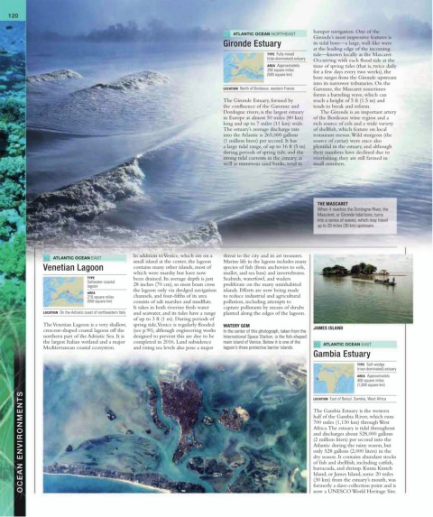
               crescent-shaped coastal lagoon off the   (see p.90), although engineering works   In the center of this photograph, taken from the   JAMES ISLAND
               northern part of the Adriatic Sea. It is   designed to prevent this are due to be   International Space Station, is the fish-shaped
               the largest Italian wetland and a major   completed in 2016. Land subsidence   main island of Venice. Below it is one of the   ATLANTIC OCEAN EAST
               Mediterranean coastal ecosystem.    and rising sea levels also pose a major   lagoon’s three protective barrier islands.
                                                                                                        Gambia Estuary

                                                                                                                       TYPE  Salt-wedge
                                                                                                                       (river-dominated) estuary
                                                                                                                       AREA  Approximately
                                                                                                                       400 square miles
                                                                                                                       (1,000 square km)
        OCEAN ENVIRONMENTS                                                                              half of the Gambia River, which runs
                                                                                                        LOCATION  East of Banjul, Gambia, West Africa
                                                                                                        The Gambia Estuary is the western

                                                                                                        700 miles (1,130 km) through West
                                                                                                        Africa. The estuary is tidal throughout
                                                                                                        and discharges about 528,000 gallons
                                                                                                        (2 million liters) per second into the
                                                                                                        Atlantic during the rainy season, but
                                                                                                        only 528 gallons (2,000 liters) in the
                                                                                                        dry season. It contains abundant stocks
                                                                                                        of fish and shellfish, including catfish,
                                                                                                        barracuda, and shrimp. Kunta Kinteh
                                                                                                        Island, or James Island, some 20 miles
                                                                                                        (30 km) from the estuary’s mouth, was
                                                                                                        formerly a slave-collection point and is
                                                                                                        now a UNESCO World Heritage Site.
   117   118   119   120   121   122   123   124   125   126   127