
Page 125 - (DK) Ocean - The Definitive Visual Guide
P. 125
ESTUARIES AND LAGOONS 123
PACIFIC OCEAN SOUTHWEST because he was sceptical of being able
to sail out again if he entered it.
Doubtful Sound Doubtful Sound is the second-longest
and the deepest of the New Zealand
TYPE fiords, with a maximum depth of
Highly stratified estuary;
fiord 421m (1,380ft). It receives fresh water
from a hydroelectric power station at
AREA
70 square km its head and from a huge 6,000m
(30 square miles) (236in) of rainfall annually. Like all
fiords, it contains fresh water in its top
LOCATION West of Dunedin, southwestern South few metres and a much denser, colder,
Island, New Zealand saltier layer below. There is little
mixing between the two. Doubtful
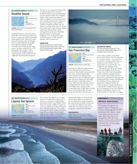
Doubtful Sound is one of 14 major Sound is home to Bottlenose
fiords that were formed 15,000 years Dolphins, New Zealand Fur Seals,
ago in a scenic part of New Zealand’s and many species of fish, starfish,
South Island. Some 40km (25 miles) sponges, and sea anemones.
long and opening onto the Tasman
Sea, it is surrounded by steep hills SOUND VIEW
from which hundreds of small This view of the head of Doubtful Sound,
waterfalls descend during the rainy looking towards the open ocean, is from the PACIFIC OCEAN NORTHEAST OAKLAND BAY BRIDGE
season. Its name originated in 1770 hills of the south-central region of New Thick fog surrounds the lower half of the
during the first voyage to New Zealand’s South Island. San Francisco Bay San Francisco–Oakland Bay Bridge, one of
Zealand by the English explorer five bridges that cross the bay.
Captain James Cook (1728–79). He TYPE
called the fiord Doubtful Harbour Partially mixed tectonic some surface outflow of brackish
estuary
water to the Pacific. San Francisco Bay
AREA
1,200 square km is a tectonic estuary – one caused by
(460 square miles) movement at tectonic faults (lines of
weakness) in the Earth’s crust, of
LOCATION Central California, western USA which there are several in the area,
notably the San Andreas Fault.
San Francisco Bay, the largest estuary During the past 150 years, human
on North America’s west coast, activity has resulted in the loss of
consists of four smaller, interconnected 90 per cent of the bay’s surrounding
bays. One of these, Suisun Bay, marshy wetland, a greatly reduced
receives fresh water drained from flow of fresh water (which has been
about 40 per cent of California’s land diverted for agricultural purposes), and
area. This water flows into San Pablo contamination by sewage and effluent.
Bay and then Central Bay, where it Nevertheless, the bay remains an
mixes with salt water that has entered important ecological habitat. Its
at depth from the Pacific Ocean via waters are home to large numbers of
the Golden Gate channel. From economically valuable marine species,
Central Bay, there is little flow of fresh such as Dungeness Crab and California
water to the largest body of water, Halibut, and millions of geese and
South San Francisco Bay, but there is ducks annually use the bay as a refuge.
PACIFIC OCEAN EAST The Laguna San Ignacio is a coastal significantly higher at its head than HUMAN IMPACT
lagoon in northwestern Mexico best at its mouth, where it connects to
Laguna San Ignacio known as a sanctuary and breeding the sea. Apart from whale watching, WHALE WATCHING
ground for Pacific Gray Whales. Latin the main human activities in the area
TYPE America’s largest wildlife sanctuary, it are small-scale fisheries and oyster
Hypersaline coastal The Laguna San Ignacio is a
lagoon is also an important feeding habitat for cultivation. In 1993, the lagoon was popular whale-watching site.
four endangered species of sea turtle. designated a World Heritage Site.
AREA Between January and March, large
360 square km The lagoon, which is 40km (25 miles) numbers of Gray Whales can be
(140 square miles) long and on average 9km (6 miles) LAGOON BEACH found there. The whales, which
wide, receives only occasional inflows Waves break on the shore at San Ignacio often approach boats, use the
LOCATION On the Pacific coast of the Baja California of fresh water, and its evaporative Lagoon, which is surrounded by a landscape
Peninsula, Mexico, southeast of Mexicali upper part of the lagoon for
losses are high. Its salinity is therefore of sparse desert scrub. giving birth, while the lower
lagoon is where males and females
look for mates. Females swim
with their calves in the middle
part of the lagoon. OCEAN ENVIRONMENTS